
Mapa topográfico Drayton Grant Park at Burger Hill
Mapa interactivo
Haga clic en el mapa para ver la altitud.
Acerca de este mapa
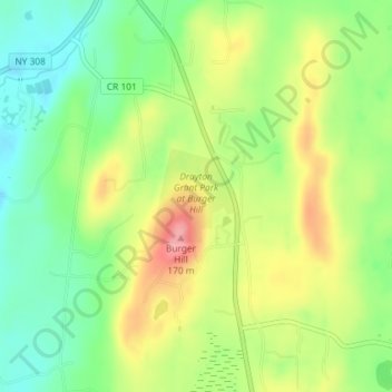
Nombre: Mapa topográfico Drayton Grant Park at Burger Hill, altitud, relieve.
Altitud media: 102 m
Altitud mínima: 54 m
Altitud máxima: 165 m
Otros mapas topográficos
Haga clic en un mapa para ver su topografía, su altitud y su relieve.
Rhinecliff
United States > New York > Dutchess County > Town of Rhinebeck
Rhinecliff, Town of Rhinebeck, Dutchess County, New York, 12574, United States
Altitud media: 19 m