
Mapa topográfico Rhinecliff
Mapa interactivo
Haga clic en el mapa para ver la altitud.
Acerca de este mapa
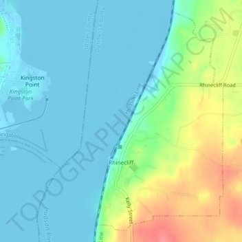
Nombre: Mapa topográfico Rhinecliff, altitud, relieve.
Altitud media: 19 m
Altitud mínima: -9 m
Altitud máxima: 73 m
The hamlet is demarcated by large agricultural and wooded area to the north, east, and south, and bounded by the Hudson River on the west. Steep topography, formed by contorted slate ridges and valleys, define the site-specific and seemingly random orientation of the small, frame nineteenth-century houses and winding narrow roads. The hamlet had a mid-nineteenth century building boom, but its boundaries and building density have changed very little over the last one hundred years.
Otros mapas topográficos
Haga clic en un mapa para ver su topografía, su altitud y su relieve.
Drayton Grant Park at Burger Hill
United States > New York > Dutchess County > Town of Rhinebeck
Drayton Grant Park at Burger Hill, Town of Rhinebeck, Dutchess County, New York, United States
Altitud media: 102 m