
Mapa topográfico Vermont
Mapa interactivo
Haga clic en el mapa para ver la altitud.
Acerca de este mapa
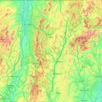
Nombre: Mapa topográfico Vermont, altitud, relieve.
Lugar: Vermont, United States (42.72696 -73.43774 45.01667 -71.46539)
Altitud media: 348 m
Altitud mínima: -2 m
Altitud máxima: 1,893 m
The topography and climate make sections of Vermont subject to large-scale flooding. Incidents include the Great Vermont Flood of 1927, which killed 84 and damaged much of the state's infrastructure, the flood of 1973, which covered many of the state's roads in the southeast, and Tropical Storm Irene in 2011, which caused substantial damage throughout the state. In response to the 1927 flood, the Federal government funded construction of six flood control dams in the state, run by the Army Corps of Engineers. These extreme rain and flooding events are expected to get worse with climate change.
Otros mapas topográficos
Haga clic en un mapa para ver su topografía, su altitud y su relieve.
Houston
United States > Texas > Harris County
Houston, Harris County, Texas, United States
Altitud media: 25 m
Boulder
United States > Colorado > Boulder County
Boulder, Boulder County, Colorado, United States
Altitud media: 1,785 m
Los Angeles
Los Angeles, Los Angeles County, California, United States
Altitud media: 241 m
The Woodlands
United States > Texas > Montgomery County
The Woodlands, Montgomery County, Texas, United States
Altitud media: 47 m
Spokane
United States > Washington > Spokane County
Spokane, Spokane County, Washington, United States
Altitud media: 655 m
Lancaster County
Lancaster County, Pennsylvania, United States
Altitud media: 158 m
Hudson River
Hudson River, New Jersey, 12834:12871, United States
Altitud media: 297 m
Fort Worth
United States > Texas > Tarrant County
Fort Worth, Tarrant County, Texas, United States
Altitud media: 212 m
Brooklyn
United States > New York > New York
Brooklyn, Kings County, New York, United States
Altitud media: 9 m
New Orleans
United States > Louisiana > Orleans Parish
New Orleans, Orleans Parish, Louisiana, United States
Altitud media: 1 m
Sequoia National Park
United States > California > Tulare County
Sequoia National Park, Tulare County, California, United States
Altitud media: 2,515 m
Tomball
United States > Texas > Harris County
Tomball, Harris County, Texas, 77375, United States
Altitud media: 52 m
Queens County
United States > New York > New York
Queens County, New York, United States
Altitud media: 11 m
Black Hills
United States > South Dakota > Pennington County
Black Hills, Pennington County, South Dakota, United States
Altitud media: 1,894 m
Saint Johns County
Saint Johns County, Florida, United States
Altitud media: 6 m