
Mapa topográfico Nebraska
Mapa interactivo
Haga clic en el mapa para ver la altitud.
Acerca de este mapa
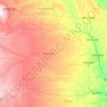
Nombre: Mapa topográfico Nebraska, altitud, relieve.
Lugar: Nebraska, United States (39.99998 -104.05352 43.00127 -95.30805)
Altitud media: 747 m
Altitud mínima: 255 m
Altitud máxima: 2,159 m
Nebraska is composed of two major land regions: the Dissected Till Plains and the Great Plains. The easternmost portion of the state was scoured by Ice Age glaciers; the Dissected Till Plains were left after the glaciers retreated. The Dissected Till Plains is a region of gently rolling hills; Omaha and Lincoln are in this region. The Great Plains occupy most of western Nebraska, with the region consisting of several smaller, diverse land regions, including the Sandhills, the Pine Ridge, the Rainwater Basin, the High Plains and the Wildcat Hills. Panorama Point, at 5,424 feet (1,653 m), is Nebraska's highest point; though despite its name and elevation, it is a relatively low rise near the Colorado and Wyoming borders. A past tourism slogan for the state of Nebraska was "Where the West Begins" (it has since been changed to "Honestly, it's not for everyone"). Locations given for the beginning of the "West" in Nebraska include the Missouri River, the intersection of 13th and O Streets in Lincoln (where it is marked by a red brick star), the 100th meridian, and Chimney Rock.
Otros mapas topográficos
Haga clic en un mapa para ver su topografía, su altitud y su relieve.
Houston
United States > Texas > Harris County
Houston, Harris County, Texas, United States
Altitud media: 25 m
Georgetown
United States > Texas > Georgetown
Georgetown, Williamson County, Texas, United States
Altitud media: 219 m
Fort Worth
United States > Texas > Tarrant County
Fort Worth, Tarrant County, Texas, United States
Altitud media: 212 m
Bay Mills
United States > Michigan > Chippewa County
Bay Mills, Bay Mills Township, Chippewa County, Michigan, 49715, United States
Altitud media: 182 m
Seattle
United States > Washington > King County
Seattle, King County, Washington, United States
Altitud media: 40 m
The Woodlands
United States > Texas > Montgomery County
The Woodlands, Montgomery County, Texas, United States
Altitud media: 47 m
Sarasota
United States > Florida > Sarasota County
Sarasota, Sarasota County, Florida, United States
Altitud media: 7 m
Jacksonville
United States > Florida > Duval County
Jacksonville, Duval County, Florida, United States
Altitud media: 10 m
Sequoia National Park
United States > California > Tulare County
Sequoia National Park, Tulare County, California, United States
Altitud media: 2,515 m
New Orleans
United States > Louisiana > Orleans Parish
New Orleans, Orleans Parish, Louisiana, United States
Altitud media: 1 m
Buncombe County
United States > North Carolina
Buncombe County, North Carolina, United States
Altitud media: 839 m
Central Park
United States > New York > New York County > New York
Central Park, New York County, New York, United States
Altitud media: 26 m
Morgantown
United States > West Virginia > Monongalia County
Morgantown, Monongalia County, West Virginia, United States
Altitud media: 337 m
Boca Raton
United States > Florida > Palm Beach County > Boca Raton
Boca Raton, Palm Beach County, Florida, 33432, United States
Altitud media: 4 m
Fort Lauderdale
United States > Florida > Broward County
Fort Lauderdale, Broward County, Florida, United States
Altitud media: 5 m
Texarkana
United States > Texas > Bowie County
Texarkana, Bowie County, Texas, United States
Altitud media: 99 m
Ridgefield
United States > Connecticut > Western Connecticut Planning Region
Ridgefield, Western Connecticut Planning Region, Connecticut, 06877, United States
Altitud media: 183 m
Parker
United States > Colorado > Douglas County
Parker, Douglas County, Colorado, 80134, United States
Altitud media: 1,845 m
Carmel
United States > Indiana > Hamilton County
Carmel, Hamilton County, Indiana, United States
Altitud media: 253 m
Queens County
United States > New York > New York
Queens County, New York, United States
Altitud media: 11 m