
Mapa topográfico Montana
Mapa interactivo
Haga clic en el mapa para ver la altitud.
Acerca de este mapa
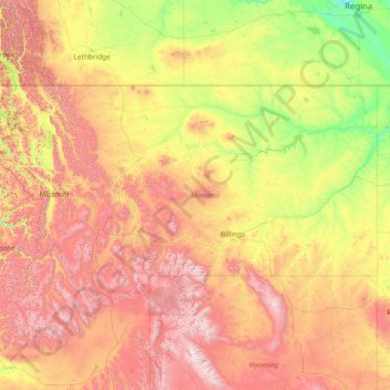
Nombre: Mapa topográfico Montana, altitud, relieve.
Lugar: Montana, United States (44.35792 -116.04923 49.00111 -104.03956)
Altitud media: 1,357 m
Altitud mínima: 552 m
Altitud máxima: 4,034 m
The state's topography is roughly defined by the Continental Divide, which splits much of the state into distinct eastern and western regions. Most of Montana's hundred or more named mountain ranges are in the state's western half, most of which is geologically and geographically part of the northern Rocky Mountains. The Absaroka and Beartooth ranges in the state's south-central part are technically part of the Central Rocky Mountains. The Rocky Mountain Front is a significant feature in the state's north-central portion, and isolated island ranges that interrupt the prairie landscape common in the central and eastern parts of the state. About 60 percent of the state is prairie, part of the northern Great Plains.
Otros mapas topográficos
Haga clic en un mapa para ver su topografía, su altitud y su relieve.
Los Angeles
Los Angeles, Los Angeles County, California, United States
Altitud media: 241 m
Houston
United States > Texas > Harris County
Houston, Harris County, Texas, United States
Altitud media: 25 m
Jacksonville
United States > Florida > Duval County
Jacksonville, Duval County, Florida, United States
Altitud media: 10 m
Sacramento
United States > California > Sacramento County
Sacramento, Sacramento County, California, United States
Altitud media: 10 m
Brooklyn
United States > New York > New York
Brooklyn, Kings County, New York, United States
Altitud media: 9 m
Tucson
United States > Arizona > Pima County
Tucson, Pima County, Arizona, United States
Altitud media: 822 m
Spokane
United States > Washington > Spokane County
Spokane, Spokane County, Washington, United States
Altitud media: 655 m
Black Hills
United States > South Dakota > Pennington County
Black Hills, Pennington County, South Dakota, United States
Altitud media: 1,894 m
Puget Sound
United States > Washington > Edmonds
Puget Sound, Admiral Way, Edmonds, Snohomish County, Washington, 98020, United States
Altitud media: 0 m
Hudson River
Hudson River, New Jersey, 12834:12871, United States
Altitud media: 297 m
Ogden
United States > Utah > Weber County
Ogden, Weber County, Utah, United States
Altitud media: 1,498 m
Sequoia National Park
United States > California > Tulare County
Sequoia National Park, Tulare County, California, United States
Altitud media: 2,515 m
Riverside County
Riverside County, California, United States
Altitud media: 538 m
Boston
United States > Massachusetts > Suffolk County
Boston, Suffolk County, Massachusetts, United States
Altitud media: 25 m