
Haz una donación
Mapa topográfico Needville
Haga clic en el mapa para ver la altitud.
Haz una donación
Acerca de este mapa
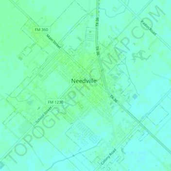
Nombre: Mapa topográfico Needville, altitud, relieve.
Lugar: Needville, Fort Bend County, Texas, United States (29.38009 -95.85600 29.41286 -95.81939)
Altitud media: 28 m
Altitud mínima: 24 m
Altitud máxima: 31 m
Haz una donación
Otros mapas topográficos
Haga clic en un mapa para ver su topografía, su altitud y su relieve.
Brazos Bend State Park
United States > Texas > Fort Bend County > Alvin
Brazos Bend State Park occupies land bordering the Brazos River and includes within its boundaries low-lying areas left over from the River's previous meanderings. Pre-Columbian inhabitants included a series of Native American groups, most notably the Karankawa. The land passed through a variety of landowners'…
Altitud media: 17 m
Haz una donación
Haz una donación
Sienna (Brazos River) Park
United States > Texas > Fort Bend County > Missouri City
Altitud media: 20 m
Haz una donación
Haz una donación