
Haz una donación
Mapa topográfico Mairang
Haga clic en el mapa para ver la altitud.
Haz una donación
Acerca de este mapa
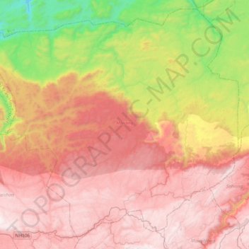
Nombre: Mapa topográfico Mairang, altitud, relieve.
Altitud media: 1,135 m
Altitud mínima: 151 m
Altitud máxima: 1,918 m
Haz una donación
Otros mapas topográficos
Haga clic en un mapa para ver su topografía, su altitud y su relieve.
Jowai
India > Meghalaya > Thadlaskein
Jowai (IPA: ʤəʊˈwaɪ) is the headquarters of the West Jaintia Hills district of the state of Meghalaya, India, and is home to the Pnar, a sub-tribe of the Khasi people. It is located on a plateau surrounded on three sides by the Myntdu river bordering Bangladesh to the south (about 50 km from the…
Altitud media: 1,332 m
Sohra (Cherrapunji)
India > Meghalaya > Shella Bholaganj
It has an average elevation of 1,430 metres (4,690 ft) and sits on a plateau in the southern part of the Khasi Hills, facing the plains of Bangladesh. The plateau rises 660 meters above the surrounding valleys.
Altitud media: 1,169 m
Haz una donación
Haz una donación
Haz una donación
Haz una donación
Haz una donación
Shillong
HQ Eastern Air Command (HQ, EAC) was shifted to Shillong on 10 Jun 63 from Kolkata and housed in the old buildings located at Nonglyer village at Upper Shillong, some 10 km from (Lower) Shillong, but at a greater altitude of around 6,000 feet AMSL. Initially a British military base, it was taken over by No. 58…
Altitud media: 1,351 m
Haz una donación
Haz una donación
Haz una donación
Nohsngithiang Falls (Seven Sisters)
India > Meghalaya > Shella Bholaganj > Nongthymmai
Altitud media: 1,043 m
Shillong
HQ Eastern Air Command (HQ, EAC) was shifted to Shillong on 10 Jun 63 from Kolkata and housed in the old buildings located at Nonglyer village at Upper Shillong, some 10 km from (Lower) Shillong, but at a greater altitude of around 6,000 feet AMSL. Initially a British military base, it was taken over by No. 58…
Altitud media: 1,351 m
Haz una donación
Shillong
HQ Eastern Air Command (HQ, EAC) was shifted to Shillong on 10 June 1963 from Kolkata and housed in the old buildings located at Nonglyer village at Upper Shillong, some 10 km (6.2 mi) from (Lower) Shillong, but at a greater altitude of around 1,800 metres (6,000 ft) AMSL. Initially a British military base, it…
Altitud media: 1,351 m
Shillong
HQ Eastern Air Command (HQ, EAC) was shifted to Shillong on 10 Jun 63 from Kolkata and housed in the old buildings located at Nonglyer village at Upper Shillong, some 10 km from (Lower) Shillong, but at a greater altitude of around 6,000 feet AMSL. Initially a British military base, it was taken over by No. 58…
Altitud media: 1,351 m
Lawkyntang (Sacred Grove)
India > Meghalaya > Khatarshnong Laitkroh > Mawphlang
Altitud media: 1,740 m
Haz una donación
Haz una donación
Sohra (Cherrapunji)
India > Meghalaya > Shella Bholaganj
It has an average elevation of 1,430 metres (4,690 ft) and sits on a plateau in the southern part of the Khasi Hills, facing the plains of Bangladesh. The plateau rises 660 meters above the surrounding valleys.
Altitud media: 1,169 m