
Haz una donación
Mapa topográfico Shillong
Haga clic en el mapa para ver la altitud.
Haz una donación
Shillong
HQ Eastern Air Command (HQ, EAC) was shifted to Shillong on 10 June 1963 from Kolkata and housed in the old buildings located at Nonglyer village at Upper Shillong, some 10 km (6.2 mi) from (Lower) Shillong, but at a greater altitude of around 1,800 metres (6,000 ft) AMSL. Initially a British military base, it was taken over by No. 58 Gorkha Regiment of the Indian Army post Independence in 1947. The Regiment was redeployed after the Sino-Indian War of 1962, making way for the IAF to step in. Only helicopters can operate from HQ, EAC, using a 12.7-hectare (31-acre) helipad.
Haz una donación
Acerca de este mapa
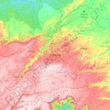
Nombre: Mapa topográfico Shillong, altitud, relieve.
Lugar: Shillong, Mylliem, East Khasi Hills, Meghalaya, 793001, India (25.41599 91.72279 25.73599 92.04279)
Altitud media: 1,351 m
Altitud mínima: 659 m
Altitud máxima: 1,958 m
Haz una donación