
Haz una donación
Mapa topográfico Dusseldorf
Haga clic en el mapa para ver la altitud.
Haz una donación
Dusseldorf
The Archbishop of Cologne's forces were wiped out by the forces of the count of Berg who were supported by citizens and farmers of Cologne and Düsseldorf, paving the way for Düsseldorf's elevation to city status, which is commemorated today by a monument on the Burgplatz. The custom of turning cartwheels is credited to the children of Düsseldorf. There are variations of the origin of the cartwheeling children. Today the symbol (Der Radschläger) represents the story and every year the Düsseldorfers celebrate by having a cartwheeling contest. After this battle the relationship between the four cities deteriorated, because they were commercial rivals; it is often said that there is a kind of hostility between the citizens of Cologne and Düsseldorf. Today, it finds its expression mainly in a humorous form (especially during the Rhineland Karneval) and in sports.
Haz una donación
Acerca de este mapa
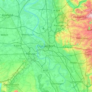
Nombre: Mapa topográfico Dusseldorf, altitud, relieve.
Lugar: Dusseldorf, North Rhine-Westphalia, Germany (51.06540 6.61631 51.38540 6.93631)
Altitud media: 63 m
Altitud mínima: 13 m
Altitud máxima: 260 m
Haz una donación
Otros mapas topográficos
Haga clic en un mapa para ver su topografía, su altitud y su relieve.
Haz una donación
Haz una donación
Meinerzhagen
Germany > North Rhine-Westphalia > Märkischer Kreis
Meinerzhagen is located in the hills of the Sauerland. The highest elevation is the Nordhelle with 652 m above sea level, the lowest elevation at the Lister dam with 319m. 56% of the town area is covered by forests.
Altitud media: 419 m
Haz una donación
Haz una donación
Siegen
Germany > North Rhine-Westphalia > Kreis Siegen-Wittgenstein
The city's total land area is roughly 115 km2 (44 sq mi). Its greatest east-west span is about 12 km (7 mi), and its greatest north-south span is about 12 km (7 mi). City limits are 48 km (30 mi) long. Siegen lies at a median elevation of 290 m (951 ft) above sea level. The city's greatest elevation is the…
Altitud media: 346 m
Haz una donación
33813
Germany > North Rhine-Westphalia > Kreis Lippe > Oerlinghausen > Oerlinghausen
Altitud media: 226 m
Haz una donación
Hemer
Germany > North Rhine-Westphalia > Märkischer Kreis
Hemer is located at the north end of the Sauerland near the Ruhr river. The highest elevation, at 546 metres (1,791 feet), is in the Balver Wald in the south of the city. The lowest elevation, at 160 metres (520 feet), is at the Edelburg in the northeast.
Altitud media: 326 m
Haz una donación
Niedersetzen
Germany > North Rhine-Westphalia > Kreis Siegen-Wittgenstein > Siegen
Altitud media: 321 m
Haz una donación
Rheda-Wiedenbrück
Germany > North Rhine-Westphalia > Kreis Gütersloh
The length of the city border is 50,2 km, the highest elevation at 105m and the lowest point at 66m above mean sea level.
Altitud media: 80 m
Haz una donación
Haz una donación
Haz una donación
Haz una donación
Haz una donación
Haz una donación
Lüdenscheid
Germany > North Rhine-Westphalia > Lüdenscheid
Lüdenscheid is located on the saddle of the watershed between the Lenne and Volme rivers which both empty into the Ruhr river (which subsequently flows into the Rhine), with three smaller valleys leading to them. The saddle has a height of 420 meters, higher elevations on the watershed are an unnamed hilltop…
Altitud media: 384 m
Haz una donación
Haz una donación
Langenfeld (Rheinland)
Germany > North Rhine-Westphalia > Kreis Mettmann > Langenfeld (Rheinland)
Altitud media: 55 m
Oer-Erkenschwick
Germany > North Rhine-Westphalia > Kreis Recklinghausen > Oer-Erkenschwick
Altitud media: 80 m
Haz una donación
Haz una donación
Haz una donación
Rommerskirchen
Germany > North Rhine-Westphalia > Rhein-Kreis Neuss > Rommerskirchen
Altitud media: 77 m
Haz una donación