
Gracias por apoyar a este sitio ❤️
Haz una donación
Haz una donación
Mapa topográfico Lügde
Haga clic en el mapa para ver la altitud.
Gracias por apoyar a este sitio ❤️
Haz una donación
Haz una donación
Acerca de este mapa
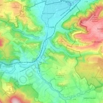
Nombre: Mapa topográfico Lügde, altitud, relieve.
Lugar: Lügde, Kreis Lippe, North Rhine-Westphalia, Germany (51.90982 9.18605 51.97769 9.28623)
Altitud media: 196 m
Altitud mínima: 89 m
Altitud máxima: 400 m
Gracias por apoyar a este sitio ❤️
Haz una donación
Haz una donación
Otros mapas topográficos
Haga clic en un mapa para ver su topografía, su altitud y su relieve.
Horn-Bad Meinberg
Germany > North Rhine-Westphalia > Kreis Lippe
In the municipality are the two highest peaks of the Eggegebirge, the Lipp Velmerstot (441 m) and the Prussian Velmerstot with about (464 m) above sea level and the highest elevation of the Teutoburg forest, the Barnacken with (446 m). The deepest point of the metropolitan area is (125 m). Between the…
Altitud media: 240 m