
Mapa topográfico Coquitlam
Mapa interactivo
Haga clic en el mapa para ver la altitud.
Acerca de este mapa
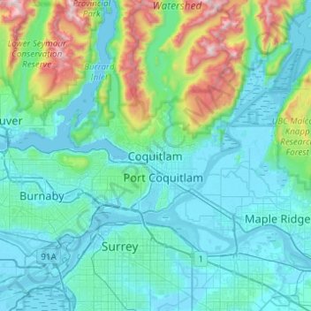
Nombre: Mapa topográfico Coquitlam, altitud, relieve.
Altitud media: 230 m
Altitud mínima: -4 m
Altitud máxima: 1,532 m
Southwest Coquitlam comprises the original core of the city, with Maillardville and Fraser River industrial sector giving way to the large residential areas of Austin Heights, colloquially referred to as "The Bump" due to its high and flat plateau topography. These older residences, with larger property dimensions, are increasingly being torn down and replaced with newer and larger homes. The Poirier Street area was the city's original recreational centre with the Coquitlam Sports Centre, Chimo Aquatic and Fitness Centre, and sports fields located there, while City Hall was previously located further south in Maillardville.
Otros mapas topográficos
Haga clic en un mapa para ver su topografía, su altitud y su relieve.
Town Centre Park
Canada > British Columbia > Metro Vancouver Regional District > Coquitlam
Town Centre Park, River Springs, Coquitlam, Metro Vancouver Regional District, British Columbia, Canada
Altitud media: 62 m
Mundy Park
Canada > British Columbia > Metro Vancouver Regional District > Coquitlam
Mundy Park, River Heights, Coquitlam, Metro Vancouver Regional District, British Columbia, Canada
Altitud media: 139 m