
Haz una donación
Mapa topográfico Feldberg
Haga clic en el mapa para ver la altitud.
Haz una donación
Feldberg
Feldberg is a municipality in the district of Breisgau-Hochschwarzwald in Baden-Württemberg in southern Germany. It is located near the Feldberg, the highest summit in Baden-Württemberg. It comprises the settlements of Altglashütten, Neuglashütten, Falkau, Bärental, and Feldberg. At an elevation of 1,277 m, the last is considered the highest village in Germany.
Haz una donación
Acerca de este mapa
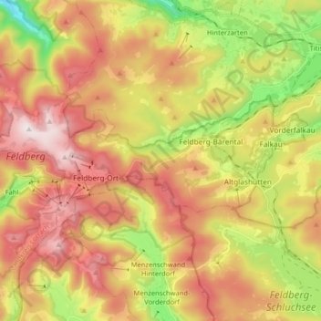
Nombre: Mapa topográfico Feldberg, altitud, relieve.
Altitud media: 1,071 m
Altitud mínima: 609 m
Altitud máxima: 1,496 m
Haz una donación
Otros mapas topográficos
Haga clic en un mapa para ver su topografía, su altitud y su relieve.
Oberried
Germany > Baden-Württemberg > Landkreis Breisgau-Hochschwarzwald
The Schauinsland (literally "look-into-the-country"; near Freiburg im Breisgau, Germany) is a mountain in the Black Forest with an elevation of 1,284 m (4,213 ft) above sea level. It is a popular destination for day trips. Due to the high amount of silver mining, it was previously known as "Erzkasten"…
Altitud media: 1,068 m