
Gracias por apoyar a este sitio ❤️
Haz una donación
Haz una donación
Mapa topográfico New Eagle
Haga clic en el mapa para ver la altitud.
Gracias por apoyar a este sitio ❤️
Haz una donación
Haz una donación
Acerca de este mapa
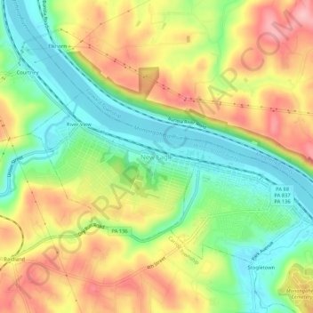
Nombre: Mapa topográfico New Eagle, altitud, relieve.
Lugar: New Eagle, Washington County, Pennsylvania, United States (40.18785 -79.96699 40.22785 -79.92699)
Altitud media: 290 m
Altitud mínima: 221 m
Altitud máxima: 371 m
Gracias por apoyar a este sitio ❤️
Haz una donación
Haz una donación
Otros mapas topográficos
Haga clic en un mapa para ver su topografía, su altitud y su relieve.
Gracias por apoyar a este sitio ❤️
Haz una donación
Haz una donación
Gracias por apoyar a este sitio ❤️
Haz una donación
Haz una donación
Mount Pleasant Township
United States > Pennsylvania > Washington County
The McGugin Tunnel is located at latitude - longitude coordinates of N 40.28674 and W -80.33173. The nearest major town is Hickory, Pennsylvania, where it passes under Pennsylvania Route 18. The tunnel is at an elevation of 1,263 feet (385 m).
Altitud media: 362 m
Gracias por apoyar a este sitio ❤️
Haz una donación
Haz una donación
West Middletown
United States > Pennsylvania > Washington County > West Middletown
Altitud media: 361 m