
Mapa topográfico Ridgeland
Mapa interactivo
Haga clic en el mapa para ver la altitud.
Acerca de este mapa
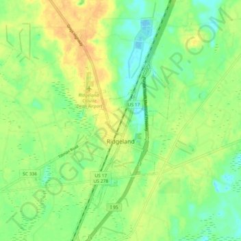
Nombre: Mapa topográfico Ridgeland, altitud, relieve.
Lugar: Ridgeland, Jasper County, South Carolina, United States (32.44908 -80.99926 32.52542 -80.95989)
Altitud media: 15 m
Altitud mínima: -3 m
Altitud máxima: 32 m
Ridgeland is in northeastern Jasper County, with the center of town sitting on a low ridge at an elevation of 62 feet (19 m) above sea level. According to the United States Census Bureau, the town has a total area of 44.7 square miles (115.8 km2), of which 44.4 square miles (115.1 km2) are land and 0.3 square miles (0.7 km2), or 0.59%, are water. The town's area as of 2010 was 18 times greater than its 2000 area of 2.4 square miles (6.3 km2). The town limits now extend east into Beaufort County as far as the west bank of the Broad River.
Otros mapas topográficos
Haga clic en un mapa para ver su topografía, su altitud y su relieve.
Latitude Margaritaville
United States > South Carolina > Jasper County > Hardeeville
Latitude Margaritaville, Hardeeville, Jasper County, South Carolina, 29927, United States
Altitud media: 4 m
Hardeeville
United States > South Carolina > Jasper County
Hardeeville, Jasper County, South Carolina, 29927, United States
Altitud media: 5 m