Geolocalizar

Mapa topográfico Bas-Rhin

Haga clic en el mapa para ver la altitud.

Bas-Rhin

Bas-Rhin (French pronunciation: [bɑ ʁɛ̃] ) is a département in Alsace which is a part of the Grand Est super-region of France. The name means 'Lower Rhine', referring to its lower altitude among the two French Rhine departments: it is downstream of the Haut-Rhin (Upper Rhine) department. Both belong to the European Upper Rhine region. It is, with the Haut-Rhin (Upper Rhine), one of the two departments of the traditional Alsace region which until 1871, also included the area now known as the Territoire de Belfort. The more populous and densely populated of the pair, it had 1,152,662 inhabitants in 2021. The prefecture is based in Strasbourg. The INSEE and Post Code is 67.

Wikipedia (CC-BY-SA 3.0)

Acerca de este mapa

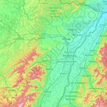
Nombre: Mapa topográfico Bas-Rhin, altitud, relieve.

Lugar: Bas-Rhin, Grand Est, Metropolitan France, France (48.12043 6.94063 49.07779 8.23285)

Altitud media: 315 m

Altitud mínima: 104 m

Altitud máxima: 1,274 m

Otros mapas topográficos

Haga clic en un mapa para ver su topografía, su altitud y su relieve.

Kapellenhof

France > Grand Est > Moselle > Hottviller

Altitud media: 322 m

Ballon d'Alsace

France > Grand Est > Haut-Rhin > Sewen

Altitud media: 994 m

Metzing

France > Grand Est > Moselle > Riche

Altitud media: 236 m

Falkenstein Castle

France > Grand Est > Moselle > Philippsbourg

In 1981, the Vosges Club (club vosgien) in Strasbourg placed a marker at the castle summit showing the altitude and directions to nearby land features.

Altitud media: 269 m

Satel

France > Grand Est > Meuse > Apremont-la-Forêt

Altitud media: 275 m

Le Mesnil le Huttier

France > Grand Est > Marne > Festigny

Altitud media: 176 m

Le Hamai

France > Grand Est > Ardennes > Villers-sur-Bar

Altitud media: 175 m

Au-dessus de Cobey

France > Grand Est > Vosges > Igney

Altitud media: 325 m

La Schlucht

France > Grand Est > Vosges > Le Valtin

Altitud media: 1,039 m

Bingle

France > Grand Est > Haut-Rhin > Eschentzwiller

Altitud media: 274 m

Rénessa

France > Grand Est > Meuse > Geville

Altitud media: 289 m

Hohrodberg

France > Grand Est > Haut-Rhin > Hohrod

Altitud media: 696 m

Kutz

France > Grand Est > Haut-Rhin > Katzenthal

Altitud media: 351 m

Richat

France > Grand Est > Ardennes > Fromelennes

Altitud media: 165 m

Saint-Mars

France > Grand Est > Haute-Marne > Louvemont

Altitud media: 152 m

Lac Blanc

France > Grand Est > Haut-Rhin > Orbey

Lac Blanc is a lake in Haut-Rhin, France. At an elevation of 1055 m, its surface area is 0.29 km².

Altitud media: 1,111 m

La Mauselaine

France > Grand Est > Vosges > Gérardmer

Altitud media: 859 m

Hamanxard

France > Grand Est > Vosges > Le Val-d'Ajol

Altitud media: 563 m

Audviller

France > Grand Est > Moselle > Wentzviller

Altitud media: 228 m

Le Motiron

France > Grand Est > Vosges > Le Val-d'Ajol

Altitud media: 553 m

Willigen

France > Grand Est > Bas-Rhin > Kilstett

Altitud media: 130 m

Prau

France > Grand Est > Ardennes > Vireux-Wallerand

Altitud media: 155 m

Pairis

France > Grand Est > Haut-Rhin > Orbey

Altitud media: 801 m

Chiers

France > Grand Est > Ardennes > La Ferté-sur-Chiers

Altitud media: 186 m

Eschwiller Mill

France > Grand Est > Moselle > Eschviller

Altitud media: 301 m

Haute Murée

France > Grand Est > Vosges > Moyenmoutier

Altitud media: 438 m

Steinmattenmuehle

France > Grand Est > Haut-Rhin > Leymen

Altitud media: 417 m

Georgea

France > Grand Est > Ardennes > L'Écaille

Altitud media: 95 m

Grand Mé

France > Grand Est > Meuse > Froidos

Altitud media: 213 m

Fourneau Neuf

France > Grand Est > Moselle > Mouterhouse

Altitud media: 282 m

Singling

France > Grand Est > Moselle

Altitud media: 326 m

Col du Donon

France > Grand Est > Bas-Rhin > Grandfontaine

Altitud media: 694 m

Remanvillers

France > Grand Est > Vosges > Ferdrupt

Altitud media: 568 m

Grand Soldat

France > Grand Est > Moselle > Abreschviller

Altitud media: 424 m

Pré des Rheims

France > Grand Est > Meuse > Bussy-la-Côte > Mussey

Altitud media: 180 m

Graufthal

France > Grand Est > Bas-Rhin > Eschbourg

Altitud media: 290 m

Col du Platzerwasel

France > Grand Est > Haut-Rhin > Mittlach

The Col du Platzerwasel (elevation 1,182 m (3,878 ft)) is a mountain pass situated in the Vosges Mountains in the Haut-Rhin department of France, between Sondernach and Le Markstein. It has been crossed occasionally during the Tour de France cycle race, including on Stage 10 of the 2014 race.

Altitud media: 1,024 m

Vaugan

France > Grand Est > Aube > Dosnon

Altitud media: 133 m

Aureil-Maison

France > Grand Est > Vosges > Lamarche

Altitud media: 394 m

Hohneck

France > Grand Est > Haut-Rhin > Stosswihr

Altitud media: 1,136 m

Wang

France > Grand Est > Haut-Rhin > Hohrod

Altitud media: 567 m

Le Solberg

France > Grand Est > Haut-Rhin > Eschbach-au-Val

Altitud media: 620 m

Clairvaux

France > Grand Est > Aube > Ville-sous-la-Ferté

Altitud media: 238 m

Grande Île

France > Grand Est > Bas-Rhin > Strasbourg

Altitud media: 145 m

Royes

France > Grand Est > Vosges > Removille

Altitud media: 352 m

Tête Pelée

France > Grand Est > Bas-Rhin > La Broque

Altitud media: 672 m

Moor

France > Grand Est > Moselle > Loudrefing

Altitud media: 241 m

Crecy

France > Grand Est > Ardennes > Brieulles-sur-Bar

Altitud media: 198 m

Longor

France > Grand Est > Meuse > Pagny-sur-Meuse

Altitud media: 270 m

Wanne

France > Grand Est > Haut-Rhin > Dietwiller

Altitud media: 282 m

Le Chêne

France > Grand Est > Vosges > Rupt-sur-Moselle

Altitud media: 576 m

Le Canar

France > Grand Est > Haute-Marne > Saints-Geosmes

Altitud media: 444 m

Su

France > Grand Est > Bas-Rhin > Soultz-les-Bains

Altitud media: 207 m

Margale

France > Grand Est > Aube > Fuligny

Altitud media: 208 m

Kreutzel

France > Grand Est > Bas-Rhin > Baerendorf

Altitud media: 275 m

Erstein-Gare

France > Grand Est > Bas-Rhin > Erstein

Altitud media: 154 m

La Mergerie

France > Grand Est > Vosges > Chef-Haut

Altitud media: 360 m

Crème

France > Grand Est > Moselle > Obreck

Altitud media: 228 m

Moirey

France > Grand Est > Meuse > Moirey-Flabas-Crépion

Altitud media: 258 m

Holbach

France > Grand Est > Moselle

Altitud media: 331 m

Lac Noir

France > Grand Est > Haut-Rhin > Orbey

Lac Noir is a lake in Orbey, Alsace, France. At an elevation of 955 m, its surface area is 0.14 km².

Altitud media: 1,052 m

Le Markstein

France > Grand Est > Haut-Rhin > Fellering

Le Markstein is a winter sports station in the Vosges mountains in France situated at an altitude of between 1,020 m (3,346 ft) and 1,268 m (4,160 ft) which is located on the Route des Crêtes. It forms a set of cross-country skiing with the Breitfirst ski-station and the Grand Ballon. The highest point is the…

Altitud media: 1,013 m

Le Clauset

France > Grand Est > Marne > Oiry

Altitud media: 79 m

Reims

France > Grand Est > Marne > Reims

Altitud media: 130 m

Forest

France > Grand Est > Ardennes > Seraincourt

Altitud media: 167 m

Richat

France > Grand Est > Ardennes > Fromelennes

Altitud media: 165 m

La Seine

France > Grand Est > Mussy-sur-Seine

Altitud media: 225 m

Roedle

France > Grand Est > Friesen

Altitud media: 379 m

La Chaussée de Damery

France > Grand Est > Marne

Altitud media: 136 m

Beaufort

France > Grand Est > Vandy

Altitud media: 182 m

Everst Garten

France > Grand Est > Moselle > Villing > Trois Maisons

Altitud media: 286 m

Richat

France > Grand Est > Ardennes > Fromelennes

Altitud media: 165 m

Candie

France > Grand Est > Marne > Cormicy

Altitud media: 79 m

Schlitte Mountain

France > Grand Est > Vosges > La Bresse

Altitud media: 1,032 m