
Gracias por apoyar a este sitio ❤️
Haz una donación
Haz una donación
Mapa topográfico Blue River
Haga clic en el mapa para ver la altitud.
Gracias por apoyar a este sitio ❤️
Haz una donación
Haz una donación
Acerca de este mapa
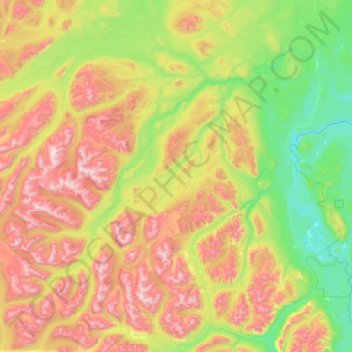
Nombre: Mapa topográfico Blue River, altitud, relieve.
Lugar: Blue River, Stikine Region, British Columbia, Canada (59.33676 -130.23046 59.79753 -128.96557)
Altitud media: 1,198 m
Altitud mínima: 639 m
Altitud máxima: 2,285 m
Gracias por apoyar a este sitio ❤️
Haz una donación
Haz una donación
Otros mapas topográficos
Haga clic en un mapa para ver su topografía, su altitud y su relieve.
Gracias por apoyar a este sitio ❤️
Haz una donación
Haz una donación
Gracias por apoyar a este sitio ❤️
Haz una donación
Haz una donación
Gracias por apoyar a este sitio ❤️
Haz una donación
Haz una donación
White Pass
Canada > British Columbia > Stikine Region
White Pass, also known as the Dead Horse Trail (elevation 873 m or 2,864 ft), is a mountain pass through the Boundary Ranges of the Coast Mountains on the border of the U.S. state of Alaska and the province of British Columbia, Canada. It leads from Skagway, Alaska, to the chain of lakes at the headwaters of…
Altitud media: 968 m
Gracias por apoyar a este sitio ❤️
Haz una donación
Haz una donación