
Mapa topográfico Lost Creek Lake
Mapa interactivo
Haga clic en el mapa para ver la altitud.
Acerca de este mapa
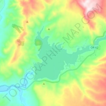
Nombre: Mapa topográfico Lost Creek Lake, altitud, relieve.
Lugar: Lost Creek Lake, Jackson County, Oregon, United States (42.66482 -122.67607 42.71425 -122.54510)
Altitud media: 729 m
Altitud mínima: 458 m
Altitud máxima: 1,282 m
The primary purpose of the dam is flood control and is operated in conjunction with Applegate Dam to regulate water flows down the river as well as to impound water for summer use. The dam is an earthfill structure with a gated spillway and contains two hydroelectric generating units with a total capacity of 49 megawatts. The hydroelectric plant has a rated flow capacity of 2,600 cubic feet per second (74 m3/s). The technologically advanced and unusual intake tower regulates water temperature by combining lake water from different depths in a mixing chamber before releasing it downstream. This serves to cool the normally warm summer water of the Rogue River, which improves conditions for fish migration and survival. The dam is 3,750 feet (1,140 m) long, 327 feet (100 m) high, with the top of the dam at an elevation of 1,882 feet (574 m) above mean sea level (MSL).The river below the dam is a popular area for easy rafting and tubing in the summer when the water is relatively warm. Joseph H. Stewart State Recreation Area is located along the southern shore of the lake. Casey State Park is located on the Rogue River below the dam.
Otros mapas topográficos
Haga clic en un mapa para ver su topografía, su altitud y su relieve.
Ashland
United States > Oregon > Jackson County
Ashland, Jackson County, Oregon, United States
Altitud media: 774 m
Trail
United States > Oregon > Jackson County
Trail, Jackson County, Oregon, 97539, United States
Altitud media: 534 m
Ruch
United States > Oregon > Jackson County
Ruch, Jackson County, Oregon, United States
Altitud media: 560 m
Applegate
United States > Oregon > Jackson County
Applegate, Jackson County, Oregon, United States
Altitud media: 501 m
Medford
United States > Oregon > Jackson County
Medford, Jackson County, Oregon, United States
Altitud media: 441 m
White City
United States > Oregon > Jackson County
White City, Jackson County, Oregon, 97503, United States
Altitud media: 404 m
Siskiyou Gap
United States > Oregon > Jackson County
Siskiyou Gap, Jackson County, Oregon, United States
Altitud media: 1,746 m
Fish Lake
United States > Oregon > Jackson County
Fish Lake, Jackson County, Oregon, United States
Altitud media: 1,456 m
Shady Cove
United States > Oregon > Jackson County
Shady Cove, Jackson County, Oregon, 97539, United States
Altitud media: 506 m
Eagle Point
United States > Oregon > Jackson County
Eagle Point, Jackson County, Oregon, 97524, United States
Altitud media: 422 m
Central Point
United States > Oregon > Jackson County
Central Point, Jackson County, Oregon, 97502, United States
Altitud media: 385 m
Buncom
United States > Oregon > Jackson County
Buncom, Jackson County, Oregon, United States
Altitud media: 654 m
Mount Ashland
United States > Oregon > Jackson County
Mount Ashland, Jackson County, Oregon, United States
Altitud media: 1,957 m
Rogue River
United States > Oregon > Jackson County
Rogue River, Jackson County, Oregon, 97537, United States
Altitud media: 362 m
Phoenix
United States > Oregon > Jackson County
Phoenix, Jackson County, Oregon, 97535, United States
Altitud media: 469 m
Wagner Butte
United States > Oregon > Jackson County
Wagner Butte, Jackson County, Oregon, United States
Altitud media: 1,848 m
Gold Hill
United States > Oregon > Jackson County
Gold Hill, Jackson County, Oregon, United States
Altitud media: 416 m
Talent
United States > Oregon > Jackson County
Talent, Jackson County, Oregon, United States
Altitud media: 516 m
Jacksonville
United States > Oregon > Jackson County
Jacksonville, Jackson County, Oregon, 97530, United States
Altitud media: 522 m