
Haz una donación
Mapa topográfico Coulter
Haga clic en el mapa para ver la altitud.
Haz una donación
Acerca de este mapa
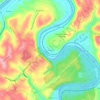
Nombre: Mapa topográfico Coulter, altitud, relieve.
Altitud media: 287 m
Altitud mínima: 219 m
Altitud máxima: 373 m
Haz una donación
Otros mapas topográficos
Haga clic en un mapa para ver su topografía, su altitud y su relieve.
Brackenridge
United States > Pennsylvania > Allegheny County
Brackenridge is located at 40°36′30″N 79°44′32″W / 40.60833°N 79.74222°W / 40.60833; -79.74222. The borough's average elevation is 827 feet (252 m) above sea level. According to the U.S. Census Bureau, the borough has a total area of 0.6 square miles (1.6 km2), of which 0.5 square miles…
Altitud media: 266 m
Haz una donación
Haz una donación
Curtisville
United States > Pennsylvania > Allegheny County > West Deer Township > Curtisville
Altitud media: 344 m
Haz una donación
Haz una donación
Haz una donación
Haz una donación
Haz una donación
Bradford Woods
United States > Pennsylvania > Allegheny County
According to the United States Census Bureau, the borough has a total area of 0.9 square miles (2.3 km2), all of it land. Its average elevation is 1,250 ft (381 m) above sea level.
Altitud media: 369 m
Avalon
United States > Pennsylvania > Allegheny County
According to the United States Census Bureau, the borough has a total area of 0.7 square miles (1.8 km2), of which 0.6 square miles (1.6 km2) is land and 0.1 square miles (0.26 km2) is water. Its average elevation is 932 feet (284 m) above sea level.
Altitud media: 275 m
Haz una donación
Baldwin
United States > Pennsylvania > Allegheny County
According to the U.S. Census Bureau, the borough has a total area of 5.9 square miles (15 km2), of which 5.8 square miles (15 km2) is land and 0.1 square miles (0.26 km2) is water. Its average elevation is 1,214 feet (370 m) above sea level.
Altitud media: 338 m
Ben Avon
United States > Pennsylvania > Allegheny County
Its average elevation is 928 feet (283 m) above sea level.
Altitud media: 263 m
Ben Avon Heights
United States > Pennsylvania > Allegheny County
According to the United States Census Bureau, the borough has a total area of 0.2 square miles (0.52 km2), all land. Its average elevation is 1,135 feet (346 m) above sea level.
Altitud media: 294 m
Haz una donación
Aspinwall
United States > Pennsylvania > Allegheny County
Aspinwall is located at 40°29′35″N 79°54′11″W / 40.49306°N 79.90306°W / 40.49306; -79.90306. According to the U.S. Census Bureau, the borough has a total area of 0.4 square miles (1.0 km2), of which 0.3 square miles (0.78 km2) is land and 0.04 square miles (0.10 km2) is water. Its average…
Altitud media: 275 m
Haz una donación
South Fayette Township
United States > Pennsylvania > Allegheny County
According to the United States Census Bureau, the township has a total area of 20.4 square miles (53 km2), of which 20.95 square miles (54.3 km2) is land and 0.05% is water. The topography is mostly wooded with small hills and floodplains on four streams. It is located 14 miles (23 km) southwest of Pittsburgh.
Altitud media: 328 m
Blawnox
United States > Pennsylvania > Allegheny County
According to the United States Census Bureau, the borough has a total area of 0.4 square miles (1.0 km2), of which 0.3 square miles (0.78 km2) is land and 0.1 square miles (0.26 km2), or 25.58%, is water. Its average elevation is 843 feet (257 m) above sea level.
Altitud media: 265 m
Haz una donación
Bell Acres
United States > Pennsylvania > Allegheny County
According to the United States Census Bureau, the borough has a total area of 5.2 square miles (13 km2), all land. Its average elevation is 965 feet (294 m) above sea level.
Altitud media: 316 m
Haz una donación
Haz una donación
Allegheny Islands State Park
United States > Pennsylvania > Allegheny County > Plum > Acmetonia
Altitud media: 259 m
Haz una donación
Haz una donación
Haz una donación
Castle Shannon
United States > Pennsylvania > Allegheny County
According to the United States Census Bureau, the borough has a total area of 1.6 square miles (4.1 km2), all of it land. Its average elevation is 1,040 feet (320 m) above sea level.
Altitud media: 354 m
Forward Township
United States > Pennsylvania > Allegheny County > Forward Township
Altitud media: 306 m
Haz una donación