
Mapa topográfico Vohburg
Mapa interactivo
Haga clic en el mapa para ver la altitud.
Acerca de este mapa
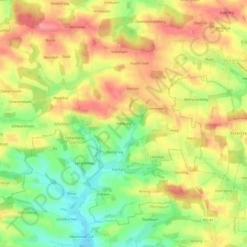
Nombre: Mapa topográfico Vohburg, altitud, relieve.
Altitud media: 482 m
Altitud mínima: 435 m
Altitud máxima: 521 m
Otros mapas topográficos
Haga clic en un mapa para ver su topografía, su altitud y su relieve.
Schleichwies
Deutschland > Bayern > Landkreis Landshut > Wurmsham
Schleichwies, Wurmsham, Velden (VGem), Landkreis Landshut, Bayern, 84189, Deutschland
Altitud media: 485 m