
Mapa topográfico Williamston
Mapa interactivo
Haga clic en el mapa para ver la altitud.
Acerca de este mapa
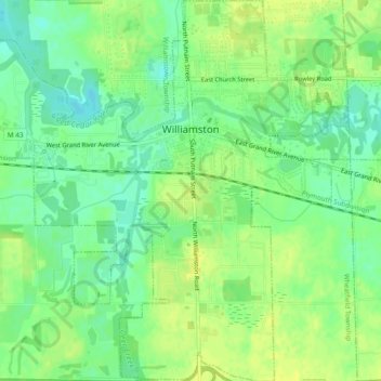
Nombre: Mapa topográfico Williamston, altitud, relieve.
Lugar: Williamston, Ingham County, Michigan, 48895, United States (42.66608 -84.30858 42.70097 -84.26359)
Altitud media: 268 m
Altitud mínima: 258 m
Altitud máxima: 276 m
Otros mapas topográficos
Haga clic en un mapa para ver su topografía, su altitud y su relieve.
Lansing
United States > Michigan > Ingham County
Lansing, Ingham County, Michigan, United States
Altitud media: 263 m
East Lansing
United States > Michigan > Ingham County
East Lansing, Ingham County, Michigan, United States
Altitud media: 261 m
Lansing Charter Township
United States > Michigan > Ingham County
Lansing Charter Township, Ingham County, Michigan, United States
Altitud media: 262 m
North Aurelius
United States > Michigan > Ingham County > North Aurelius
North Aurelius, Aurelius Township, Ingham County, Michigan, United States
Altitud media: 277 m
Mason
United States > Michigan > Ingham County > Mason
Mason, Ingham County, Michigan, 48854, United States
Altitud media: 276 m
Okemos
United States > Michigan > Ingham County > Okemos
Okemos, Meridian Charter Township, Ingham County, Michigan, United States
Altitud media: 264 m