
Mapa topográfico Poyntzpass
Mapa interactivo
Haga clic en el mapa para ver la altitud.
Acerca de este mapa
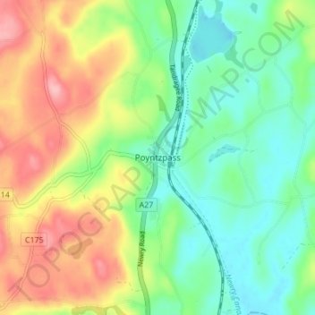
Nombre: Mapa topográfico Poyntzpass, altitud, relieve.
Altitud media: 61 m
Altitud mínima: 12 m
Altitud máxima: 138 m
Otros mapas topográficos
Haga clic en un mapa para ver su topografía, su altitud y su relieve.
Armagh
United Kingdom > Northern Ireland > County Armagh > Armagh
Armagh, County Armagh, Northern Ireland, BT61 7DJ, United Kingdom
Altitud media: 85 m
Canary
United Kingdom > Northern Ireland > County Armagh
Canary, County Armagh, Northern Ireland, United Kingdom
Altitud media: 19 m
Derrynoose
United Kingdom > Northern Ireland > County Armagh
Derrynoose, County Armagh, Northern Ireland, BT60 3EZ, United Kingdom
Altitud media: 163 m
Lurgan
United Kingdom > Northern Ireland > County Armagh
Lurgan, County Armagh, Ulster, Northern Ireland, United Kingdom
Altitud media: 48 m
Portadown
United Kingdom > Northern Ireland > County Armagh
Portadown, County Armagh, Northern Ireland, BT62 1BF, United Kingdom
Altitud media: 28 m
Madden
United Kingdom > Northern Ireland > County Armagh
Madden, County Armagh, Ulster, Northern Ireland, BT60 3LR, United Kingdom
Altitud media: 103 m
Forkhill
United Kingdom > Northern Ireland > County Armagh
Forkhill, County Armagh, Ulster, Northern Ireland, BT35 9SN, United Kingdom
Altitud media: 104 m
Armagh
United Kingdom > Northern Ireland > County Armagh > Milford
Armagh, Milford, County Armagh, Ulster, Northern Ireland, United Kingdom
Altitud media: 100 m
Richhill
United Kingdom > Northern Ireland > County Armagh
Richhill, County Armagh, Northern Ireland, BT61 9QR, United Kingdom
Altitud media: 66 m
Keady
United Kingdom > Northern Ireland > County Armagh
Keady, County Armagh, Ulster, Northern Ireland, BT60 3RW, United Kingdom
Altitud media: 158 m
Markethill
United Kingdom > Northern Ireland > County Armagh
Markethill, County Armagh, Northern Ireland, BT60 1PW, United Kingdom
Altitud media: 106 m
Craigavon
United Kingdom > Northern Ireland > County Armagh
Craigavon, County Armagh, Ulster, Northern Ireland, BT64 3AE, United Kingdom
Altitud media: 34 m
Killylea
United Kingdom > Northern Ireland > County Armagh > Armagh
Killylea, Armagh, County Armagh, Northern Ireland, BT60 4LN, United Kingdom
Altitud media: 73 m
Charlestown
United Kingdom > Northern Ireland > County Armagh
Charlestown, County Armagh, Ulster, Northern Ireland, BT62 1LR, United Kingdom
Altitud media: 16 m