
Gracias por apoyar a este sitio ❤️
Haz una donación
Haz una donación
Mapa topográfico Wernigerode
Haga clic en el mapa para ver la altitud.
Gracias por apoyar a este sitio ❤️
Haz una donación
Haz una donación
Acerca de este mapa
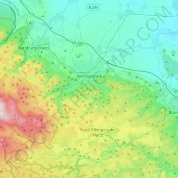
Nombre: Mapa topográfico Wernigerode, altitud, relieve.
Lugar: Wernigerode, Landkreis Harz, Saxony-Anhalt, Germany (51.75220 10.57385 51.88704 10.90049)
Altitud media: 381 m
Altitud mínima: 139 m
Altitud máxima: 1,062 m
Gracias por apoyar a este sitio ❤️
Haz una donación
Haz una donación
Otros mapas topográficos
Haga clic en un mapa para ver su topografía, su altitud y su relieve.
Brocken
Germany > Saxony-Anhalt > Landkreis Harz > Wernigerode
The Brocken, also sometimes referred to as the Blocksberg, is the highest peak in the Harz mountain range and also the highest peak in Northern Germany; it is near Schierke in the German state of Saxony-Anhalt between the rivers Weser and Elbe. Although its elevation of 1,141 metres (3,743 ft) is below alpine…
Altitud media: 963 m