
Gracias por apoyar a este sitio ❤️
Haz una donación
Haz una donación
Mapa topográfico Grintovec
Haga clic en el mapa para ver la altitud.
Gracias por apoyar a este sitio ❤️
Haz una donación
Haz una donación
Grintovec
Grintovec is the highest mountain of the Kamnik–Savinja Alps, with an elevation of 2,558 metres (8,392 ft). It is a popular location for hiking, climbing and skiing. The first recorded ascent was in 1759 by the botanist Giovanni Antonio Scopoli.
Gracias por apoyar a este sitio ❤️
Haz una donación
Haz una donación
Acerca de este mapa
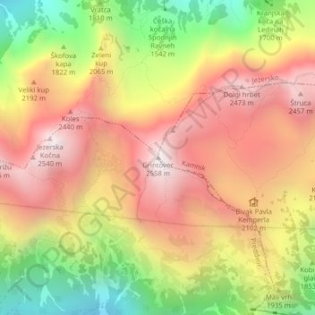
Nombre: Mapa topográfico Grintovec, altitud, relieve.
Lugar: Grintovec, Kamnik, Upravna Enota Kamnik, Slovenia (46.35708 14.53535 46.35718 14.53545)
Altitud media: 1,959 m
Altitud mínima: 1,228 m
Altitud máxima: 2,538 m
Gracias por apoyar a este sitio ❤️
Haz una donación
Haz una donación