
Mapa topográfico Lakeview
Mapa interactivo
Haga clic en el mapa para ver la altitud.
Acerca de este mapa
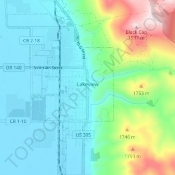
Nombre: Mapa topográfico Lakeview, altitud, relieve.
Lugar: Lakeview, Lake County, Oregon, 97630, United States (42.16423 -120.37558 42.21158 -120.33630)
Altitud media: 1,562 m
Altitud mínima: 1,440 m
Altitud máxima: 1,960 m
Lakeview is a town in Lake County, Oregon, United States. The population was 2,418 at the 2020 census. It is the county seat of Lake County. The city bills itself as the "Tallest Town in Oregon" because of its elevation, 4,802 feet (1,464 m) above sea level. Lakeview is situated in the Goose Lake Valley at the foot of the Warner Mountains and at the edge of Oregon's high desert country. Its economy is based on agriculture, lumber production, and government activities. In addition, tourism is an increasingly important part of the city's economy. Oregon's Outback Scenic Byway passes through Lakeview.
Otros mapas topográficos
Haga clic en un mapa para ver su topografía, su altitud y su relieve.
Fort Rock
United States > Oregon > Lake County
Fort Rock, Lake County, Oregon, United States
Altitud media: 1,326 m
Foster Lake
United States > Oregon > Lake County
Foster Lake, Lake County, Oregon, United States
Altitud media: 1,816 m
Christmas Valley
United States > Oregon > Lake County
Christmas Valley, Lake County, Oregon, 97641, United States
Altitud media: 1,316 m
Adel
United States > Oregon > Lake County
Adel, Lake County, Oregon, 97620, United States
Altitud media: 1,467 m
Green Creek
United States > Oregon > Lake County
Green Creek, Lake County, Oregon, United States
Altitud media: 1,657 m