
Haz una donación
Mapa topográfico Bhowali
Haga clic en el mapa para ver la altitud.
Haz una donación
Bhowali
Bhowali (Kumaoni: Bhoāli)[bʱəʋaːli] is a town and municipal board in Nainital District in the state of Uttarakhand, India. It is situated at a distance of 11 km (6.8 mi) from the city of Nainital, the district headquarters; at an average elevation of 1,654 m (5,427 ft) from sea level. It is the seat of Bhowali tehsil, one of the eight subdivisions of Nainital district.
Haz una donación
Acerca de este mapa
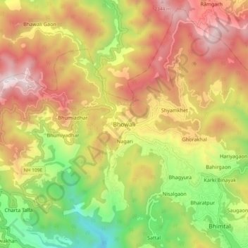
Nombre: Mapa topográfico Bhowali, altitud, relieve.
Lugar: Bhowali, Nainital, Uttarakhand, India (29.34350 79.47884 29.42350 79.55884)
Altitud media: 1,672 m
Altitud mínima: 866 m
Altitud máxima: 2,449 m
Haz una donación
Otros mapas topográficos
Haga clic en un mapa para ver su topografía, su altitud y su relieve.
Nainital
India > Uttarakhand > Nainital
Nainital is located in the Kumaon foothills of the outer Himalayas at a distance of 276 km (171 mi) from the state capital Dehradun and 314 km (195 mi) from New Delhi, the capital of India. Situated at an altitude of 1,938 metres (6,358 ft) above sea level, the town is set in a valley containing an eye-shaped…
Altitud media: 2,059 m
Haz una donación
Nainital
India > Uttarakhand > Nainital
Nainital is located in the Kumaon foothills of the outer Himalayas at a distance of 276 km (171 mi) from the state capital Dehradun and 314 km (195 mi) from New Delhi, the capital of India. Situated at an altitude of 1,938 metres (6,358 ft) above sea level, the town is set in a valley containing an eye-shaped…
Altitud media: 2,059 m