
Mapa topográfico Maysville
Mapa interactivo
Haga clic en el mapa para ver la altitud.
Acerca de este mapa
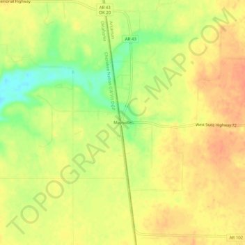
Nombre: Mapa topográfico Maysville, altitud, relieve.
Lugar: Maysville, Benton County, Arkansas, 72747, United States (36.38369 -94.62189 36.42369 -94.58189)
Altitud media: 323 m
Altitud mínima: 296 m
Altitud máxima: 337 m
Otros mapas topográficos
Haga clic en un mapa para ver su topografía, su altitud y su relieve.
Bentonville
United States > Arkansas > Benton County
Bentonville, Benton County, Arkansas, United States
Altitud media: 387 m
Monte Ne Shores
United States > Arkansas > Benton County
Monte Ne Shores, Benton County, Arkansas, United States
Altitud media: 380 m
Lowell
United States > Arkansas > Benton County
Lowell, Benton County, Arkansas, United States
Altitud media: 404 m
Gravette
United States > Arkansas > Benton County
Gravette, Benton County, Arkansas, United States
Altitud media: 356 m
Prairie Creek
United States > Arkansas > Benton County > Rogers
Prairie Creek, Rogers, Benton County, Arkansas, United States
Altitud media: 389 m
Garfield
United States > Arkansas > Benton County
Garfield, Benton County, Arkansas, 72732, United States
Altitud media: 453 m
Hiwasse
United States > Arkansas > Benton County > Gravette
Hiwasse, Gravette, Benton County, Arkansas, 72739, United States
Altitud media: 394 m
Siloam Springs
United States > Arkansas > Benton County
Siloam Springs, Benton County, Arkansas, 72761, United States
Altitud media: 339 m
Blowing Springs Bike & Fitness Park
United States > Arkansas > Benton County > Bella Vista
Blowing Springs Bike & Fitness Park, Bella Vista, Benton County, Arkansas, 72715, United States
Altitud media: 351 m
Centerton
United States > Arkansas > Benton County
Centerton, Benton County, Arkansas, 72719, United States
Altitud media: 393 m
Norwood
United States > Arkansas > Benton County
Norwood, Benton County, Arkansas, United States
Altitud media: 347 m
Bentonville
United States > Arkansas > Benton County > Bentonville > Bentonville
Bentonville, Benton County, Arkansas, 72712, United States
Altitud media: 383 m
Bella Vista
United States > Arkansas > Benton County
Bella Vista, Benton County, Arkansas, 72715, United States
Altitud media: 372 m
Rago
United States > Arkansas > Benton County > Bella Vista > Rago
Rago, Bella Vista, Benton County, Arkansas, 72715, United States
Altitud media: 378 m
Rogers
United States > Arkansas > Benton County
Rogers, Benton County, Arkansas, United States
Altitud media: 393 m