
Haz una donación
Mapa topográfico Taytay
Haga clic en el mapa para ver la altitud.
Haz una donación
Acerca de este mapa
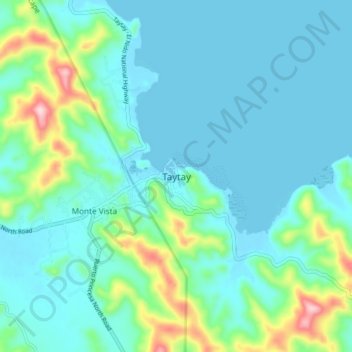
Nombre: Mapa topográfico Taytay, altitud, relieve.
Lugar: Taytay, Palawan, Mimaropa, 5312, Philippines (10.78502 119.47788 10.86502 119.55788)
Altitud media: 55 m
Altitud mínima: -1 m
Altitud máxima: 302 m
Haz una donación
Otros mapas topográficos
Haga clic en un mapa para ver su topografía, su altitud y su relieve.
Busuanga
Elevation The municipality's western and central portions are predominantly rough and mountainous with rolling to hilly terrain. A part of this is the Chinabayan Mountain and Wayan Range that still support extensive parches of Molave forest and Cogon grassland (features which are dominant in the locale).…
Altitud media: 16 m
Cagayancillo
There are neither mountain ranges nor forested areas in the municipality. A hilly portion in the north-eastern part of the main island has a slope of 3-82%. The other areas are flat with the highest elevation around 2 to 3 meters. The majority of the island has a sandy loam soil not enough to support a forest.
Altitud media: 0 m
Haz una donación
Haz una donación
Haz una donación
Haz una donación
Cuyo
Cuyo Island is the largest island of the Cuyo Archipelago, about 13 kilometers (8.1 mi) long, 7.5 kilometers (4.7 mi) wide, and with an area of 57 square kilometers (22 sq mi). Mount Bonbon with an elevation of 817 feet (249 m) is the highest mountain in Cuyo island. The Island is under the jurisdiction of the…
Altitud media: 0 m
Haz una donación
Haz una donación
Haz una donación
Haz una donación
Likas Island
Philippines > Palawan > Kalayaan
West York Island, also known as Likas Island (Filipino: Pulo ng Likas, lit. 'Island of Naturality'; Mandarin Chinese: 西月島/西月岛; pinyin: Xīyuè Dǎo; Vietnamese: đảo Bến Lạc), and several other names. With an area of 18.6 hectares (46 acres), it is the third largest of the naturally…
Altitud media: 0 m
Haz una donación
Haz una donación
Haz una donación
Haz una donación
Haz una donación
Haz una donación
Haz una donación
Haz una donación
Busuanga
Elevation The municipality's western and central portions are predominantly rough and mountainous with rolling to hilly terrain. A part of this is the Chinabayan Mountain and Wayan Range that still support extensive parches of Molave forest and Cogon grassland (features which are dominant in the locale).…
Altitud media: 16 m
Haz una donación
Kalayaan
The islets that comprise the municipality are generally flat. The highest ground elevation is approximately 2 metres (6 ft 7 in) above sea level.
Altitud media: 0 m
Busuanga
Elevation The municipality's western and central portions are predominantly rough and mountainous with rolling to hilly terrain. A part of this is the Chinabayan Mountain and Wayan Range that still support extensive parches of Molave forest and Cogon grassland (features which are dominant in the locale).…
Altitud media: 16 m
Haz una donación
Haz una donación
Haz una donación
Haz una donación
Cuyo
Cuyo Island is the largest island of the Cuyo Archipelago, about 13 kilometres (8.1 mi) long, 7.5 kilometres (4.7 mi) wide, and with an area of 57 square kilometres (22 sq mi). Mount Bonbon with an elevation of 817 ft (249 m) is the highest mountain in Cuyo island. The Island is under the jurisdiction of the…
Altitud media: 0 m
Haz una donación