
Haz una donación
Mapa topográfico Yreka
Haga clic en el mapa para ver la altitud.
Haz una donación
Acerca de este mapa
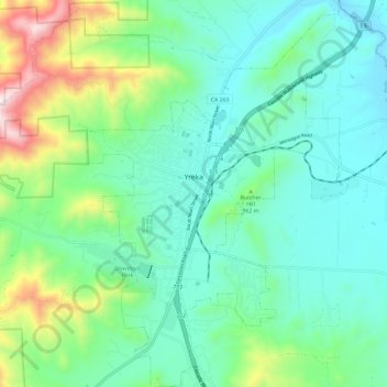
Nombre: Mapa topográfico Yreka, altitud, relieve.
Lugar: Yreka, Siskiyou County, California, 96097, United States (41.68441 -122.67057 41.77304 -122.58626)
Altitud media: 917 m
Altitud mínima: 734 m
Altitud máxima: 1,496 m
Haz una donación
Otros mapas topográficos
Haga clic en un mapa para ver su topografía, su altitud y su relieve.
Mount Shasta
United States > California > Siskiyou County
Mount Shasta (Shasta: Waka-nunee-Tuki-wuki; Karuk: Úytaahkoo) is a potentially active volcano at the southern end of the Cascade Range in Siskiyou County, California. At an elevation of 14,179 feet (4,321.8 meters), it is the second-highest peak in the Cascades and the fifth-highest in the state. Mount Shasta…
Altitud media: 3,717 m
Mount Shasta
United States > California > Siskiyou County
Mount Shasta (/ˈʃæstə/ SHASS-tə; Shasta: Waka-nunee-Tuki-wuki; Karuk: Úytaahkoo) is a potentially active stratovolcano at the southern end of the Cascade Range in Siskiyou County, California. At an elevation of 14,179 ft (4,322 m), it is the second-highest peak in the Cascades and the fifth-highest in…
Altitud media: 3,717 m
Haz una donación
Haz una donación
Haz una donación
McCloud
United States > California > Siskiyou County > McCloud
McCloud is located at 41°15′17″N 122°8′11″W / 41.25472°N 122.13639°W / 41.25472; -122.13639 (41.254682, -122.136321) on the southern slope of Mount Shasta, at an elevation of 3,271 feet (997 m) above sea level.
Altitud media: 1,010 m
Mount Shasta
United States > California > Siskiyou County
Mount Shasta (/ˈʃæstə/ SHASS-tə; Shasta: Waka-nunee-Tuki-wuki; Karuk: Úytaahkoo) is a potentially active stratovolcano at the southern end of the Cascade Range in Siskiyou County, California. At an elevation of 14,179 ft (4,322 m), it is the second-highest peak in the Cascades and the fifth-highest in…
Altitud media: 3,717 m
Mount Shasta
United States > California > Siskiyou County
Mount Shasta (/ˈʃæstə/ SHASS-tə; Shasta: Waka-nunee-Tuki-wuki; Karuk: Úytaahkoo) is a potentially active volcano at the southern end of the Cascade Range in Siskiyou County, California. At an elevation of 14,179 feet (4,321.8 meters), it is the second-highest peak in the Cascades and the fifth-highest in…
Altitud media: 3,717 m
Haz una donación
Shastina
United States > California > Siskiyou County
Shastina is a satellite cone of Mount Shasta. It is the second youngest of four overlapping volcanic cones which together form the most voluminous stratovolcano in the Cascade Range. At 12,335 feet (3,760 m), Shastina is taller than Mount Adams and would rank as the third highest volcano in the Cascades behind…
Altitud media: 3,386 m
Mount Shasta City Park
United States > California > Siskiyou County > Mount Shasta
Altitud media: 1,126 m
Haz una donación
Dunsmuir
United States > California > Siskiyou County
At an elevation of approximately 2,350 feet (720 m) above sea level, a unique setting is created by the Sacramento River in which class 3 whitewater rapids are usually created during summer run off through a town of about 2,000 residents. In plain view from some of the city's public streets, this may be one of…
Altitud media: 1,075 m
Haz una donación
Haz una donación