
Gracias por apoyar a este sitio ❤️
Haz una donación
Haz una donación
Mapa topográfico Neureuth
Haga clic en el mapa para ver la altitud.
Gracias por apoyar a este sitio ❤️
Haz una donación
Haz una donación
Acerca de este mapa
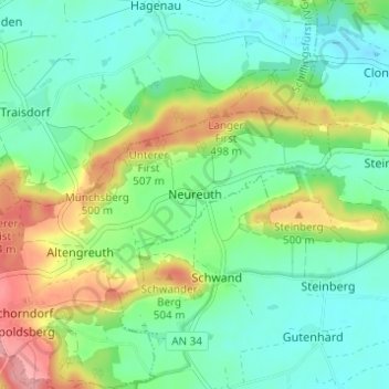
Nombre: Mapa topográfico Neureuth, altitud, relieve.
Altitud media: 459 m
Altitud mínima: 426 m
Altitud máxima: 528 m
Gracias por apoyar a este sitio ❤️
Haz una donación
Haz una donación
Otros mapas topográficos
Haga clic en un mapa para ver su topografía, su altitud y su relieve.
Schlosspark Schillingsfürst
Deutschland > Bayern > Landkreis Ansbach > Schillingsfürst > Stilzendorf
Altitud media: 489 m