
Mapa topográfico Burton
Mapa interactivo
Haga clic en el mapa para ver la altitud.
Acerca de este mapa
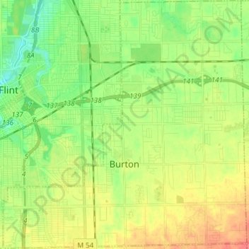
Nombre: Mapa topográfico Burton, altitud, relieve.
Lugar: Burton, Genesee County, Michigan, United States (42.95958 -83.69282 43.04820 -83.57375)
Altitud media: 237 m
Altitud mínima: 215 m
Altitud máxima: 265 m
Otros mapas topográficos
Haga clic en un mapa para ver su topografía, su altitud y su relieve.
Genesee Charter Township
United States > Michigan > Genesee County
Genesee Charter Township, Genesee County, Michigan, United States
Altitud media: 233 m
Swartz Creek
United States > Michigan > Genesee County
Swartz Creek, Genesee County, Michigan, United States
Altitud media: 239 m
Flint Charter Township
United States > Michigan > Genesee County
Flint Charter Township, Genesee County, Michigan, 48532, United States
Altitud media: 234 m
Flint
United States > Michigan > Genesee County
Flint, Genesee County, Michigan, United States
Altitud media: 236 m