
Haz una donación
Mapa topográfico Parrs Mill
Haga clic en el mapa para ver la altitud.
Haz una donación
Acerca de este mapa
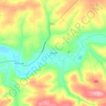
Nombre: Mapa topográfico Parrs Mill, altitud, relieve.
Lugar: Parrs Mill, Columbia County, Pennsylvania, United States (40.88703 -76.49217 40.92703 -76.45217)
Altitud media: 255 m
Altitud mínima: 173 m
Altitud máxima: 345 m
Haz una donación
Otros mapas topográficos
Haga clic en un mapa para ver su topografía, su altitud y su relieve.
Haz una donación
Haz una donación
Sugarloaf Township
United States > Pennsylvania > Columbia County
Sugarloaf Township is located in the northeast corner of Columbia County, and is bordered to the north by Sullivan County and to the east by Luzerne County. Most of the township is rolling hills, with elevations ranging from 850 to 1,300 feet (260 to 400 m), while the northern part of the township contains the…
Altitud media: 393 m
Haz una donación
Haz una donación
Lightstreet
United States > Pennsylvania > Columbia County > Scott Township > Lightstreet
Altitud media: 210 m
Haz una donación
Numidia
United States > Pennsylvania > Columbia County > Locust Township > Numidia
Altitud media: 298 m
Haz una donación
Wilburton Number One
United States > Pennsylvania > Columbia County > Conyngham Township
Wilburton Number One is on the top of a mountain, at an elevation of 1,540 feet (470 m). Wilburton Number One's land is a mixture of forest and residential.
Altitud media: 439 m
Haz una donación
Hemlock Creek
United States > Pennsylvania > Columbia County > Buckhorn > Buckhorn
Altitud media: 207 m