
Haz una donación
Mapa topográfico Export
Haga clic en el mapa para ver la altitud.
Haz una donación
Export
Export is characterized by a varied terrain that reflects its location in the Allegheny Plateau region. The borough sits at an average elevation of around 1,122 feet (342 meters) and features rolling hills and valleys typical of southwestern Pennsylvania's topography. The surrounding landscape is marked by gentle slopes and a mix of wooded areas and open fields, providing a picturesque setting that transitions into more rugged terrain as you move toward the nearby hills. The area is also influenced by local waterways, which have carved out small valleys and contribute to the region's rich biodiversity.
Haz una donación
Acerca de este mapa
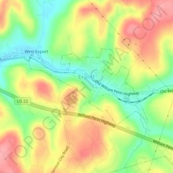
Nombre: Mapa topográfico Export, altitud, relieve.
Altitud media: 342 m
Altitud mínima: 289 m
Altitud máxima: 393 m
Haz una donación
Otros mapas topográficos
Haga clic en un mapa para ver su topografía, su altitud y su relieve.
Donegal Lake
United States > Pennsylvania > Westmoreland County > Donegal Township
Altitud media: 493 m
Morewood
United States > Pennsylvania > Westmoreland County > East Huntingdon Township
Altitud media: 357 m
Haz una donación
Chestnut Ridge
United States > Pennsylvania > Westmoreland County > Fairfield Township
Altitud media: 466 m
Circleville
United States > Pennsylvania > Westmoreland County > North Huntingdon Township
Altitud media: 333 m
Twin Lakes Park
United States > Pennsylvania > Westmoreland County > Hempfield Township > Luxor > Georges Station
Altitud media: 367 m
Haz una donación
United
United States > Pennsylvania > Westmoreland County > Mount Pleasant Township
Altitud media: 326 m
Turkeytown
United States > Pennsylvania > Westmoreland County > South Huntingdon Township
Altitud media: 317 m
Alverton
United States > Pennsylvania > Westmoreland County > East Huntingdon Township
Altitud media: 361 m
Haz una donación
Buckeye
United States > Pennsylvania > Westmoreland County > East Huntingdon Township
Altitud media: 338 m
Tarrs
United States > Pennsylvania > Westmoreland County > East Huntingdon Township
Altitud media: 356 m
Collinsburg
United States > Pennsylvania > Westmoreland County > Rostraver Township
Altitud media: 282 m
Painter Rock Hill
United States > Pennsylvania > Westmoreland County > Donegal Township
Altitud media: 781 m
Haz una donación
Acme
United States > Pennsylvania > Westmoreland County > Mount Pleasant Township
Altitud media: 585 m
Bessemer
United States > Pennsylvania > Westmoreland County > East Huntingdon Township
Altitud media: 342 m
Haz una donación
Southwest
United States > Pennsylvania > Westmoreland County > Mount Pleasant Township
Altitud media: 336 m
Maplewood Terrace
United States > Pennsylvania > Westmoreland County > Hempfield Township > Maplewood Terrace
Altitud media: 346 m
Bessemer
United States > Pennsylvania > Westmoreland County > East Huntingdon Township > Bessemer
Altitud media: 342 m
Camp Jo-Ann
United States > Pennsylvania > Westmoreland County > Murrysville > Camp Jo-Ann
Altitud media: 343 m
Haz una donación
Keystone State Park
United States > Pennsylvania > Westmoreland County > Derry Township
Altitud media: 352 m
Yukon
United States > Pennsylvania > Westmoreland County > South Huntingdon Township
Altitud media: 315 m