
Mapa topográfico Port Washington
Mapa interactivo
Haga clic en el mapa para ver la altitud.
Acerca de este mapa
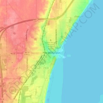
Nombre: Mapa topográfico Port Washington, altitud, relieve.
Altitud media: 205 m
Altitud mínima: 172 m
Altitud máxima: 252 m
The city is located on the western shore of Lake Michigan. In northern and southern parts of the city, the coastline is characterized by clay bluffs ranging from 80 feet (24 meters) to 130 feet (40 meters) in height with deep ravines where streams flow into the lake. Clay bluffs are a geological formation characteristic of the Lake Michigan shoreline, and are found in few other areas of the world. Much of the coastline adjacent to the bluffs has mixed gravel and sand beaches. Port Washington's historic downtown in the central part of the city is in the Sauk Creek valley, at a lower elevation than the rest of the city. The valley is a break in the bluffs, providing easy access to the lakeshore, which attracted early settlers to the area. Port Washington's artificial harbor, dredged in 1871 with subsequently constructed breakwaters, is located at the mouth of Sauk Creek, adjacent to downtown.
Otros mapas topográficos
Haga clic en un mapa para ver su topografía, su altitud y su relieve.
Grafton Centennial Park
United States > Wisconsin > Ozaukee County > Grafton
Grafton Centennial Park, Grafton, Town of Grafton, Ozaukee County, Wisconsin, United States
Altitud media: 232 m
Saukville
United States > Wisconsin > Ozaukee County
Saukville, Ozaukee County, Wisconsin, 53080, United States
Altitud media: 238 m
Mequon
United States > Wisconsin > Ozaukee County
Mequon, Ozaukee County, Wisconsin, United States
Altitud media: 223 m
Harrington Beach State Park
United States > Wisconsin > Ozaukee County > Lake Church
Harrington Beach State Park, Lake Church, Town of Belgium, Ozaukee County, Wisconsin, United States
Altitud media: 194 m
Fredonia
United States > Wisconsin > Ozaukee County
Fredonia, Ozaukee County, Wisconsin, United States
Altitud media: 251 m
Cedarburg
United States > Wisconsin > Ozaukee County
Cedarburg, Ozaukee County, Wisconsin, 53012, United States
Altitud media: 247 m
Town of Grafton
United States > Wisconsin > Ozaukee County
Town of Grafton, Ozaukee County, Wisconsin, United States
Altitud media: 203 m
Port Washington
United States > Wisconsin > Ozaukee County > Port Washington > Port Washington
Port Washington, Ozaukee County, Wisconsin, 53074, United States
Altitud media: 205 m
Decker Corner
United States > Wisconsin > Ozaukee County > Decker Corner
Decker Corner, Town of Cedarburg, Ozaukee County, Wisconsin, United States
Altitud media: 262 m
Cedar Creek
United States > Wisconsin > Ozaukee County
Cedar Creek, Ozaukee County, Wisconsin, 53202-3519, United States
Altitud media: 250 m
Grafton
United States > Wisconsin > Ozaukee County
Grafton, Ozaukee County, Wisconsin, 53024, United States
Altitud media: 238 m