
Haz una donación
Mapa topográfico Chaillol 1600
Haga clic en el mapa para ver la altitud.
Haz una donación
Acerca de este mapa
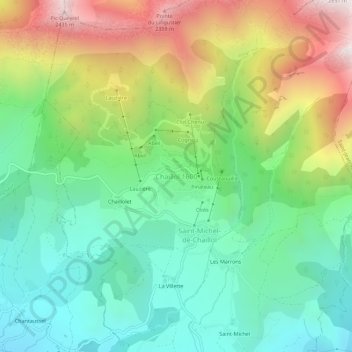
Nombre: Mapa topográfico Chaillol 1600, altitud, relieve.
Altitud media: 1,665 m
Altitud mínima: 1,225 m
Altitud máxima: 2,470 m
Haz una donación
Otros mapas topográficos
Haga clic en un mapa para ver su topografía, su altitud y su relieve.
Gap
France > Provence-Alpes-Côte d'Azur > Hautes-Alpes
The cover of morainic debris is omnipresent in the Sillon de Gap but is not the only vestige of the Quaternary glaciation. There is also the typical topography of glacial valleys. The location of the town of Gap corresponds to an Ombilic glaciaire, where large quantities of clay were deposited. Upstream lies…
Altitud media: 1,146 m
Vallouise
France > Provence-Alpes-Côte d'Azur > Hautes-Alpes > Vallouise-Pelvoux
Altitud media: 2,378 m
Haz una donación
Risoul
France > Provence-Alpes-Côte d'Azur > Hautes-Alpes
The resort has 55 ski lifts, including a cable car and 14 chairs. These give it an uplift capacity of 57,000 skiers per hour. The resort is linked to Vars through the Forêt Blanche ski area giving a total of 180 km (110 mi) of ski runs situated between 1650 and 2750 metres altitude.
Altitud media: 1,764 m
Haz una donación
Haz una donación
Saint-Eusèbe-en-Champsaur
France > Provence-Alpes-Côte d'Azur > Hautes-Alpes > Aubessagne
Altitud media: 1,029 m
Haz una donación
Haz una donación