
Mapa topográfico Sandwich
Mapa interactivo
Haga clic en el mapa para ver la altitud.
Acerca de este mapa
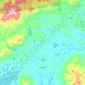
Nombre: Mapa topográfico Sandwich, altitud, relieve.
Altitud media: 373 m
Altitud mínima: 155 m
Altitud máxima: 1,200 m
According to the United States Census Bureau, the town has a total area of 94.1 square miles (243.8 km2), of which 90.9 square miles (235.4 km2) are land and 3.3 square miles (8.5 km2) are water, comprising 3.47% of the town. Sandwich is drained to the east by the Bearcamp and Cold rivers, to the northwest by the Beebe River, to the southwest by Squam Lake, and to the south by the Red Hill River. The Bearcamp and Cold rivers are part of the Saco River watershed, draining east into Maine, while the remainder of the town is part of the Merrimack River watershed, draining south to Massachusetts. Mount Israel, elevation 2,630 feet (802 m) above sea level, is at the center. Part of the Squam Mountains is in the west. Part of the Sandwich Range is in the north, including the 3,993-foot (1,217 m) Sandwich Mountain (also known as Sandwich Dome), the highest point in town as well as in Carroll County.
Otros mapas topográficos
Haga clic en un mapa para ver su topografía, su altitud y su relieve.
Eaton
United States > New Hampshire > Carroll County
Eaton, Carroll County, New Hampshire, 03832, United States
Altitud media: 262 m
Ossipee
United States > New Hampshire > Carroll County
Ossipee, Carroll County, New Hampshire, United States
Altitud media: 217 m
Flat Mountain
United States > New Hampshire > Carroll County > Sandwich
Flat Mountain, Sandwich, Carroll County, New Hampshire, United States
Altitud media: 629 m
Moultonborough
United States > New Hampshire > Carroll County
Moultonborough, Carroll County, New Hampshire, United States
Altitud media: 243 m
Albany
United States > New Hampshire > Carroll County > Albany
Albany, Carroll County, New Hampshire, United States
Altitud media: 276 m
Bayle Mountain
United States > New Hampshire > Carroll County > Ossipee
Bayle Mountain, Ossipee, Carroll County, New Hampshire, United States
Altitud media: 405 m
Bartlett
United States > New Hampshire > Carroll County
Bartlett, Carroll County, New Hampshire, United States
Altitud media: 493 m
Whitton Pond
United States > New Hampshire > Carroll County > Albany
Whitton Pond, Albany, Carroll County, New Hampshire, United States
Altitud media: 273 m
Wolfeboro
United States > New Hampshire > Carroll County
Wolfeboro, Carroll County, New Hampshire, United States
Altitud media: 213 m
Albany
United States > New Hampshire > Carroll County > Albany
Albany, Carroll County, New Hampshire, 03818, United States
Altitud media: 409 m
Tamworth
United States > New Hampshire > Carroll County > Tamworth
Tamworth, Carroll County, New Hampshire, United States
Altitud media: 263 m
Conway
United States > New Hampshire > Carroll County
Conway, Carroll County, New Hampshire, United States
Altitud media: 256 m
Freedom
United States > New Hampshire > Carroll County
Freedom, Carroll County, New Hampshire, 03836, United States
Altitud media: 224 m