
Haz una donación
Mapa topográfico Taunus
Haga clic en el mapa para ver la altitud.
Haz una donación
Taunus
Hintertaunus is the name given to the area north of the Hoher Taunus up to the Lahn valley. The landscape here is lower and less mountainous than in the southern Taunus. Between the valleys, some of which are quite deep, there are pronounced plateaus (leveled areas) with heavy agricultural use. Since mostly only the slopes of the valley are forested, the Hintertaunus is generally more open. The landscape of the Hintertaunus is more inconsistent because of its different elevations. This is clearly evident in the eastern Hintertaunus. Here, for example, there is a high-altitude landscape with dense forest cover, a harsher climate and poor soil in the Pferdskopf-Bergland; but also the Usinger basin, a gently undulating, open basin landscape with fertile soil and a balanced climate.
Haz una donación
Acerca de este mapa
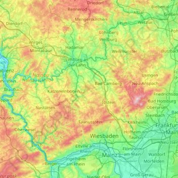
Nombre: Mapa topográfico Taunus, altitud, relieve.
Lugar: Taunus, Hesse, Germany (49.97429 7.57840 50.57366 8.73413)
Altitud media: 280 m
Altitud mínima: 63 m
Altitud máxima: 872 m
Haz una donación
Otros mapas topográficos
Haga clic en un mapa para ver su topografía, su altitud y su relieve.
Rhön
The High Rhön (German: Hohe Rhön or Hochrhön) is that part of the central Rhön that lies in Hesse, Bavaria, and to a lesser extent in Thuringia; it covers an area of 344 km2 (132.8 sq mi) Landscape fact files by the BfN (c.f. section on Natural region division) and is up to 950.0 m (3,117 ft) and whose…
Altitud media: 409 m
Haz una donación
Haz una donación