
Mapa topográfico Saddle Yoke
Mapa interactivo
Haga clic en el mapa para ver la altitud.
Acerca de este mapa
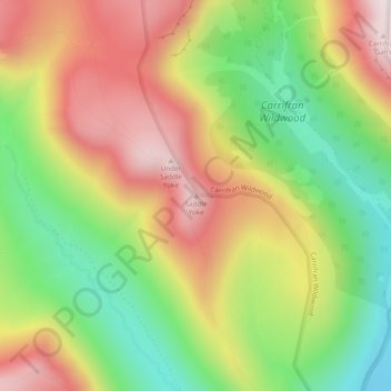
Nombre: Mapa topográfico Saddle Yoke, altitud, relieve.
Altitud media: 447 m
Altitud mínima: 155 m
Altitud máxima: 756 m
Otros mapas topográficos
Haga clic en un mapa para ver su topografía, su altitud y su relieve.
Knockvennie Smithy
United Kingdom > Scotland > Dumfries and Galloway
Knockvennie Smithy, Dumfries and Galloway, Scotland, DG7 3NX, United Kingdom
Altitud media: 121 m
Rough Firth
United Kingdom > Scotland > Dumfries and Galloway > Kippford
Rough Firth, Kippford, Dumfries and Galloway, Scotland, DG5 4LJ, United Kingdom
Altitud media: 29 m
Evertown
United Kingdom > Scotland > Dumfries and Galloway
Evertown, Dumfries and Galloway, Scotland, DG14 0AB, United Kingdom
Altitud media: 88 m
Colt Hill
United Kingdom > Scotland > Dumfries and Galloway
Colt Hill, Dumfries and Galloway, Scotland, DG3 4NN, United Kingdom
Altitud media: 470 m
Milton
United Kingdom > Scotland > Dumfries and Galloway
Milton, Dumfries and Galloway, Scotland, DG2 8QT, United Kingdom
Altitud media: 123 m
White Loch
United Kingdom > Scotland > Dumfries and Galloway
White Loch, Dumfries and Galloway, Scotland, United Kingdom
Altitud media: 58 m
Gatelawbridge
United Kingdom > Scotland > Dumfries and Galloway > Thornhill
Gatelawbridge, Thornhill, Dumfries and Galloway, Scotland, DG3 5EA, United Kingdom
Altitud media: 155 m
River Nith
United Kingdom > Scotland > Dumfries and Galloway
River Nith, Dumfries and Galloway, Scotland, United Kingdom
Altitud media: 264 m
Corsock
United Kingdom > Scotland > Dumfries and Galloway
Corsock, Dumfries and Galloway, Scotland, DG7 3DN, United Kingdom
Altitud media: 156 m
Bran Rig
United Kingdom > Scotland > Dumfries and Galloway
Bran Rig, Dumfries and Galloway, Scotland, DG11 2NU, United Kingdom
Altitud media: 196 m
Garlieston
United Kingdom > Scotland > Dumfries and Galloway
Garlieston, Dumfries and Galloway, Scotland, DG8 8BW, United Kingdom
Altitud media: 13 m
Whithorn
United Kingdom > Scotland > Dumfries and Galloway
Whithorn, Dumfries and Galloway, Scotland, DG8 8PN, United Kingdom
Altitud media: 56 m
Morton Castle
United Kingdom > Scotland > Dumfries and Galloway > Thornhill
Morton Castle, Burn Brae, Thornhill, Dumfries and Galloway, Scotland, DG3 5DY, United Kingdom
Altitud media: 190 m
Crocketford
United Kingdom > Scotland > Dumfries and Galloway
Crocketford, Dumfries and Galloway, Scotland, DG2 8RA, United Kingdom
Altitud media: 148 m
Courance
United Kingdom > Scotland > Dumfries and Galloway
Courance, Dumfries and Galloway, Scotland, DG11 1TP, United Kingdom
Altitud media: 113 m
Moniaive
United Kingdom > Scotland > Dumfries and Galloway
Moniaive, Dumfries and Galloway, Scotland, DG3 4HN, United Kingdom
Altitud media: 179 m
Palnackie
United Kingdom > Scotland > Dumfries and Galloway
Palnackie, Dumfries and Galloway, Scotland, DG7 1PG, United Kingdom
Altitud media: 38 m
Kirkpatrick Fleming
United Kingdom > Scotland > Dumfries and Galloway
Kirkpatrick Fleming, Dumfries and Galloway, Scotland, DG11 3AZ, United Kingdom
Altitud media: 59 m
Drumlanrig Castle
United Kingdom > Scotland > Dumfries and Galloway
Drumlanrig Castle, Red Route, Dumfries and Galloway, Scotland, DG3 4AQ, United Kingdom
Altitud media: 119 m
Castle Kennedy
United Kingdom > Scotland > Dumfries and Galloway
Castle Kennedy, Dumfries and Galloway, Scotland, United Kingdom
Altitud media: 24 m
Torthorwald
United Kingdom > Scotland > Dumfries and Galloway
Torthorwald, Dumfries and Galloway, Scotland, DG1 3PT, United Kingdom
Altitud media: 85 m
Kirkinner
United Kingdom > Scotland > Dumfries and Galloway
Kirkinner, Dumfries and Galloway, Scotland, DG8 9AL, United Kingdom
Altitud media: 33 m
Burnhead
United Kingdom > Scotland > Dumfries and Galloway
Burnhead, Dumfries and Galloway, Scotland, DG2 0RX, United Kingdom
Altitud media: 73 m
Black Esk
United Kingdom > Scotland > Dumfries and Galloway
Black Esk, Dumfries and Galloway, Scotland, United Kingdom
Altitud media: 231 m
Carsluith Castle
United Kingdom > Scotland > Dumfries and Galloway
Carsluith Castle, A75, Dumfries and Galloway, Scotland, DG7 2EY, United Kingdom
Altitud media: 59 m
Lochmaben Castle
United Kingdom > Scotland > Dumfries and Galloway > Lochmaben
Lochmaben Castle, Castle Loch Walk, Lochmaben, Dumfries and Galloway, Scotland, DG11 1JE, United Kingdom
Altitud media: 48 m
Shearington
United Kingdom > Scotland > Dumfries and Galloway
Shearington, Dumfries and Galloway, Scotland, DG1 4RT, United Kingdom
Altitud media: 22 m
Arkleton
United Kingdom > Scotland > Dumfries and Galloway
Arkleton, Dumfries and Galloway, Scotland, DG13 0HL, United Kingdom
Altitud media: 236 m
Monreith
United Kingdom > Scotland > Dumfries and Galloway
Monreith, Dumfries and Galloway, Scotland, DG8 9LL, United Kingdom
Altitud media: 33 m
Loch Skeen
United Kingdom > Scotland > Dumfries and Galloway
Loch Skeen, Dumfries and Galloway, Scotland, United Kingdom
Altitud media: 608 m
Dumfries
United Kingdom > Scotland > Dumfries and Galloway
Dumfries, Dumfries and Galloway, Scotland, DG1 1HS, United Kingdom
Altitud media: 25 m
Twynholm
United Kingdom > Scotland > Dumfries and Galloway
Twynholm, Dumfries and Galloway, Scotland, DG6 4NS, United Kingdom
Altitud media: 79 m
Kirkcolm
United Kingdom > Scotland > Dumfries and Galloway
Kirkcolm, Dumfries and Galloway, Scotland, DG9 0NT, United Kingdom
Altitud media: 29 m
Arbigland
United Kingdom > Scotland > Dumfries and Galloway
Arbigland, Dumfries and Galloway, Scotland, DG2 8BQ, United Kingdom
Altitud media: 14 m
Kirkmaiden
United Kingdom > Scotland > Dumfries and Galloway > Drummore
Kirkmaiden, Drummore, Dumfries and Galloway, Scotland, DG9 9QP, United Kingdom
Altitud media: 58 m
Drummore
United Kingdom > Scotland > Dumfries and Galloway
Drummore, Dumfries and Galloway, Scotland, DG9 9PY, United Kingdom
Altitud media: 36 m
Southern Uplands
United Kingdom > Scotland > Dumfries and Galloway
Southern Uplands, Dumfries and Galloway, Scotland, DG10 9LH, United Kingdom
Altitud media: 161 m
Dykehead
United Kingdom > Scotland > Dumfries and Galloway > Johnstonebridge
Dykehead, Johnstonebridge, Dumfries and Galloway, Scotland, DG11 2RS, United Kingdom
Altitud media: 116 m
Johnstonebridge
United Kingdom > Scotland > Dumfries and Galloway
Johnstonebridge, Dumfries and Galloway, Scotland, DG11 1EQ, United Kingdom
Altitud media: 103 m
Scarhead
United Kingdom > Scotland > Dumfries and Galloway > Johnstonebridge
Scarhead, Johnstonebridge, Dumfries and Galloway, Scotland, DG11 1ES, United Kingdom
Altitud media: 93 m
Ruthwell
United Kingdom > Scotland > Dumfries and Galloway
Ruthwell, Dumfries and Galloway, Scotland, DG1 4NN, United Kingdom
Altitud media: 16 m
Stranraer
United Kingdom > Scotland > Dumfries and Galloway
Stranraer, Dumfries and Galloway, Scotland, DG9 7RT, United Kingdom
Altitud media: 45 m
Lochrutton Loch
United Kingdom > Scotland > Dumfries and Galloway > Lochfoot
Lochrutton Loch, Lochfoot, Dumfries and Galloway, Scotland, United Kingdom
Altitud media: 106 m
Lockerbie
United Kingdom > Scotland > Dumfries and Galloway
Lockerbie, Dumfries and Galloway, Scotland, DG11 2EU, United Kingdom
Altitud media: 96 m
Moffat
United Kingdom > Scotland > Dumfries and Galloway
Moffat, Dumfries and Galloway, Scotland, DG10 9EX, United Kingdom
Altitud media: 225 m
Fingland
United Kingdom > Scotland > Dumfries and Galloway
Fingland, Dumfries and Galloway, Scotland, DG11 2LD, United Kingdom
Altitud media: 206 m
Castle Douglas
United Kingdom > Scotland > Dumfries and Galloway
Castle Douglas, Dumfries and Galloway, Scotland, DG7 1NA, United Kingdom
Altitud media: 68 m
Durisdeer
United Kingdom > Scotland > Dumfries and Galloway
Durisdeer, Dumfries and Galloway, Scotland, DG3 5BJ, United Kingdom
Altitud media: 270 m
Penpont
United Kingdom > Scotland > Dumfries and Galloway
Penpont, Dumfries and Galloway, Scotland, DG3 4BZ, United Kingdom
Altitud media: 98 m
Langholm
United Kingdom > Scotland > Dumfries and Galloway
Langholm, Dumfries and Galloway, Scotland, DG13 0JQ, United Kingdom
Altitud media: 185 m