
Haz una donación
Mapa topográfico Primrose Lake
Haga clic en el mapa para ver la altitud.
Haz una donación
Primrose Lake
Primrose Lake has a total surface area of 444 km2 (171 sq mi), 17.7 km2 (6.8 sq mi) of which is in Alberta, and an elevation of 559 metres (1,834 ft). It lies within muskeg and the boreal forest ecozone of Canada. There are several rivers and creeks that flow into the lake with Calder River on the northern shore being the primary inflow. Martineau River is the lake's outflow and it starts on the southern shore and flows in a south-westerly direction into Cold Lake in Alberta. To the east of the lake are the Mostoos Hills. Besides the aforementioned Martineau River and Cold Lake, the waters of Primrose Lake flow through multiple rivers and lakes en route to the Churchill River, including Cold River, Pierce Lake, Lepine Lake, Lac des Îles, Waterhen River, Waterhen Lake, Beaver River, and Lac Île-à-la-Crosse.
Haz una donación
Acerca de este mapa
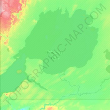
Nombre: Mapa topográfico Primrose Lake, altitud, relieve.
Altitud media: 607 m
Altitud mínima: 578 m
Altitud máxima: 719 m
Haz una donación
Otros mapas topográficos
Haga clic en un mapa para ver su topografía, su altitud y su relieve.
Haz una donación
Haz una donación
Cree Lake
Canada > Saskatchewan > Unorganized Division No. 18
Cree Lake is the remnant of a much larger proglacial lake. The proglacial lake was formed by the meltwaters of retreating continental glaciers during the last ice age about 8,700 years ago. This proglacial lake flowed south into the Churchill River drainage basin via glacial spillways. After the retreat of the…
Altitud media: 508 m
Haz una donación