
Gracias por apoyar a este sitio ❤️
Haz una donación
Haz una donación
Mapa topográfico Pruppach
Haga clic en el mapa para ver la altitud.
Gracias por apoyar a este sitio ❤️
Haz una donación
Haz una donación
Acerca de este mapa
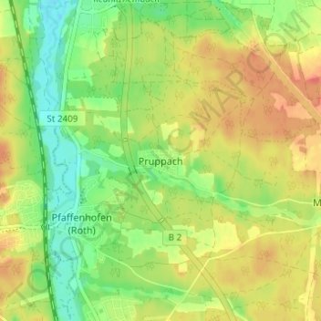
Nombre: Mapa topográfico Pruppach, altitud, relieve.
Lugar: Pruppach, Roth, Landkreis Roth, Bayern, 91154, Deutschland (49.25581 11.07623 49.29581 11.11623)
Altitud media: 346 m
Altitud mínima: 319 m
Altitud máxima: 371 m
Gracias por apoyar a este sitio ❤️
Haz una donación
Haz una donación
Otros mapas topográficos
Haga clic en un mapa para ver su topografía, su altitud y su relieve.
Rothsee (Hauptsperre)
Deutschland > Bayern > Landkreis Roth > Roth > Eichelburg
Durch ein Einlaufbauwerk am Hauptdamm fließen aus dem Main-Donau-Kanal maximal 21 m³/s zu, abgegeben werden maximal 15 m³/s Wasser. Das Kraftwerk Rothsee I nutzt das aus dem See abgegebene Wasser für zwei Turbinen: eine Durchströmturbine für maximal 1 m³/s Durchfluss, die bei niedrigen Abflüssen…
Altitud media: 382 m