
Mapa topográfico Wasaga Beach Provincial Park
Mapa interactivo
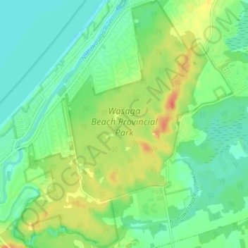
Haga clic en el mapa para ver la altitud.
Acerca de este mapa
Nombre: Mapa topográfico Wasaga Beach Provincial Park, altitud, relieve.
Altitud media: 188 m
Altitud mínima: 172 m
Altitud máxima: 214 m
The Town of Wasaga Beach covers an area of 61.13 square kilometres (23.60 sq mi) comprised predominantly of sand and loamy sand that exhibit excessive to good drainage and irregular to moderately sloping topography. The poor soil quality makes it difficult to sustain lush lawns in the town. The Canada Land Inventory for Agriculture rates the lands as predominately Class Six and Seven with primary restrictions of adverse topography, erosion damage and low natural fertility.
Otros mapas topográficos
Haga clic en un mapa para ver su topografía, su altitud y su relieve.
Wasaga Beach Provincial Park
Canada > Ontario > Simcoe County > Wasaga Beach
Wasaga Beach Provincial Park, 11, Wasaga Beach, Simcoe County, Central Ontario, Ontario, L9Z 2V9, Canada
Altitud media: 185 m
Springhurst Beach
Canada > Ontario > Simcoe County > Wasaga Beach > Springhurst Beach
Springhurst Beach, Wasaga Beach, Simcoe County, Central Ontario, Ontario, L0L 2P0, Canada
Altitud media: 184 m