
Haz una donación
Mapa topográfico Casa de Oro
Haga clic en el mapa para ver la altitud.
Haz una donación
Acerca de este mapa
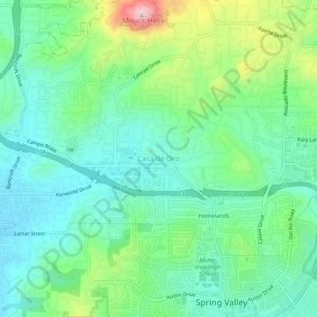
Nombre: Mapa topográfico Casa de Oro, altitud, relieve.
Altitud media: 191 m
Altitud mínima: 108 m
Altitud máxima: 405 m
Haz una donación
Otros mapas topográficos
Haga clic en un mapa para ver su topografía, su altitud y su relieve.
Alpine
United States > California > San Diego County
Alpine sits on both sides of Interstate 8 at the eastern extent of the California coastal region and the western extent of the Peninsular Ranges, about 30 miles (48 km) east of downtown San Diego, at an elevation of about 2,000 feet (610 m).
Altitud media: 581 m
Haz una donación
Encinitas
United States > California > San Diego County
Encinitas lies on rugged coastal terrace. The city is bisected by a low-lying coastal ridge that separates New and Old Encinitas. In the north of the city, the coast rises in elevation and the land is raised up in the form of many coastal bluffs. These cliffs are subject to collapsing on the narrow beach. The…
Altitud media: 32 m