
Gracias por apoyar a este sitio ❤️
Haz una donación
Haz una donación
Mapa topográfico Scheid
Haga clic en el mapa para ver la altitud.
Gracias por apoyar a este sitio ❤️
Haz una donación
Haz una donación
Scheid
Scheid is the northwesternmost place in the Vulkaneifel district. It lies roughly 1 km northwest of Hallschlag on a mountain ridge. Its elevation is 593 m above sea level.
Gracias por apoyar a este sitio ❤️
Haz una donación
Haz una donación
Acerca de este mapa
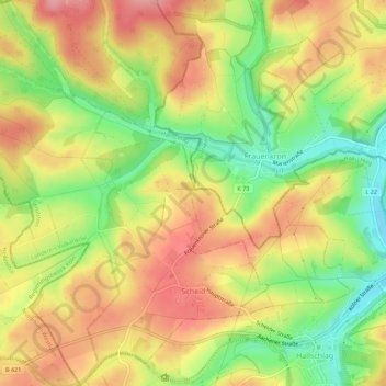
Nombre: Mapa topográfico Scheid, altitud, relieve.
Altitud media: 552 m
Altitud mínima: 487 m
Altitud máxima: 607 m
Gracias por apoyar a este sitio ❤️
Haz una donación
Haz una donación
Otros mapas topográficos
Haga clic en un mapa para ver su topografía, su altitud y su relieve.
Weinfelder Maar
Germany > Rhineland-Palatinate > Landkreis Vulkaneifel > Schalkenmehren
Altitud media: 467 m