
Haz una donación
Mapa topográfico Tatla Lake
Haga clic en el mapa para ver la altitud.
Haz una donación
Acerca de este mapa
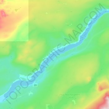
Nombre: Mapa topográfico Tatla Lake, altitud, relieve.
Altitud media: 1,080 m
Altitud mínima: 907 m
Altitud máxima: 1,619 m
Haz una donación
Otros mapas topográficos
Haga clic en un mapa para ver su topografía, su altitud y su relieve.
Anahim Lake
Canada > British Columbia > Cariboo Regional District > Area J (West Chilcotin)
Altitud media: 1,101 m
Mount Juno
Canada > British Columbia > Cariboo Regional District > Area J (West Chilcotin)
Altitud media: 2,219 m
Kondor Lake
Canada > British Columbia > Cariboo Regional District > Area J (West Chilcotin)
Altitud media: 1,718 m
Heckman Pass
Canada > British Columbia > Cariboo Regional District > Area J (West Chilcotin)
Altitud media: 1,519 m
Haz una donación
Itcha Range
Canada > British Columbia > Cariboo Regional District > Area J (West Chilcotin)
Altitud media: 1,747 m
Ilgachuz Range
Canada > British Columbia > Cariboo Regional District > Area J (West Chilcotin)
The Ilgachuz Range is a name given to an extinct shield volcano in British Columbia, Canada. It is not a mountain range in the normal sense, because it was formed as a single volcano that has been eroded for the past five million years. It lies on the Chilcotin Plateau, located some 350 kilometres (220 mi)…
Altitud media: 2,018 m
Rainbow Range
Canada > British Columbia > Cariboo Regional District > Area J (West Chilcotin)
Altitud media: 1,741 m
Nimpo Lake
Canada > British Columbia > Cariboo Regional District > Area J (West Chilcotin)
Altitud media: 1,131 m
Haz una donación
Anahim Peak
Canada > British Columbia > Cariboo Regional District > Area J (West Chilcotin)
Altitud media: 1,416 m
Puntzi Mountain
Canada > British Columbia > Cariboo Regional District > Area J (West Chilcotin)
Altitud media: 1,293 m
The Joker
Canada > British Columbia > Cariboo Regional District > Area J (West Chilcotin)
Altitud media: 2,157 m
Great Canyon
Canada > British Columbia > Cariboo Regional District > Area J (West Chilcotin)
Altitud media: 1,220 m
Haz una donación
Great Canyon
Canada > British Columbia > Cariboo Regional District > Area J (West Chilcotin)
Altitud media: 1,220 m
Map Glacier
Canada > British Columbia > Cariboo Regional District > Area J (West Chilcotin)
Altitud media: 2,037 m