
Haz una donación
Mapa topográfico Sweet Valley
Haga clic en el mapa para ver la altitud.
Haz una donación
Acerca de este mapa
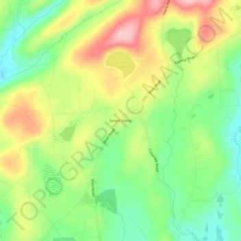
Nombre: Mapa topográfico Sweet Valley, altitud, relieve.
Altitud media: 390 m
Altitud mínima: 314 m
Altitud máxima: 487 m
Haz una donación
Otros mapas topográficos
Haga clic en un mapa para ver su topografía, su altitud y su relieve.
Pittston Township
United States > Pennsylvania > Luzerne County
According to the United States Census Bureau, the township has a total area of 13.79 square miles (35.71 km2), of which 13.77 square miles (35.66 km2) is land and 0.02 square miles (0.05 km2), or 0.15%, is water. It is the second largest community by area in Greater Pittston. The township is served by the…
Altitud media: 372 m
Haz una donación
Lake Leigh Dam (defunct)
United States > Pennsylvania > Luzerne County > Fairmount Township
Altitud media: 672 m
Haz una donación
Haz una donación
Natural Lands Trust Bear Creek Preserve - Dry Land Hill Parcel
United States > Pennsylvania > Luzerne County > Shades Glen
Altitud media: 507 m
Haz una donación
Haz una donación
Ricketts Glen State Park
United States > Pennsylvania > Luzerne County > Fairmount Township
The state's original plans for the new park included building an inn, an 18-hole golf course and country club, and a winter sports complex for skiing, ice boating, and tobogganing, as well as a beach with bathing facilities, cabins, and a tent camping area. Only the last three were actually built, all south of…
Altitud media: 588 m
Scouton Lee Park
United States > Pennsylvania > Luzerne County > Wilkes-Barre > Parsons
Altitud media: 192 m
Haz una donación