
Haz una donación
Mapa topográfico Bantayan
Haga clic en el mapa para ver la altitud.
Haz una donación
Acerca de este mapa
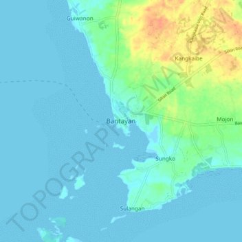
Nombre: Mapa topográfico Bantayan, altitud, relieve.
Lugar: Bantayan, Cebu, Central Visayas, 6052, Philippines (11.12669 123.67888 11.20669 123.75888)
Altitud media: 7 m
Altitud mínima: -2 m
Altitud máxima: 37 m
Haz una donación
Otros mapas topográficos
Haga clic en un mapa para ver su topografía, su altitud y su relieve.
Cordova
The surface of the town consists entirely of karstic limestone rock geologically associated with the Plio-Pleistocene Carcar Formation, dated to 2½–3 million years ago. The topography of Cordova is flat land, the highest point being only 10 metres (33 ft) above sea level.
Altitud media: 0 m
Oslob
Generally, the area's topography is hilly and rolling, dominated by open grasslands and second-growth forests. There are fairly level and rolling plateaus and valleys spread throughout the interior. These are some of the most suitable areas for upland agriculture. The highest mountain peak is 800 metres (2,600…
Altitud media: 99 m
Haz una donación
Carnaza
The island's topography includes coastal plains, mangrove swamps, lagoons and semi-rounded hills. Its coastal plain constitutes about 9.7% while semi-rounded hills constitute the biggest portion of the island covering about 14.4% of the total area. The mangrove forest has an area of about 10.1 hectares or 5.8%…
Altitud media: 0 m
Haz una donación
Haz una donación
Haz una donación
Haz una donación
Haz una donación
Haz una donación
Oslob
Generally, the area's topography is hilly and rolling, dominated by open grasslands and second-growth forests. There are fairly level and rolling plateaus and valleys spread throughout the interior. These are some of the most suitable areas for upland agriculture. The highest mountain peak is 800 metres (2,600…
Altitud media: 99 m
Haz una donación
Haz una donación
Haz una donación