
Haz una donación
Mapa topográfico Givat Yoav
Haga clic en el mapa para ver la altitud.
Haz una donación
Acerca de este mapa
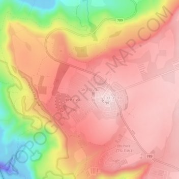
Nombre: Mapa topográfico Givat Yoav, altitud, relieve.
Altitud media: 245 m
Altitud mínima: -111 m
Altitud máxima: 370 m
Haz una donación
Otros mapas topográficos
Haga clic en un mapa para ver su topografía, su altitud y su relieve.
El Rom
Israel > North District > Golan Regional Council
The kibbutz is about ten kilometers (6.2 mi) south of Mount Hermon, at an elevation of 1,050–1,070 meters (3,440–3,510 ft) above sea level. El Rom and the nearby moshav Odem are the two Jewish settlements in Israel with the highest elevation after Nimrod.
Altitud media: 1,062 m
Haz una donación
Yehudia - Brechat HaMeshushim Site Nature Reserve
Israel > North District > Golan Regional Council
Altitud media: 91 m
Haz una donación
Avnay Eitan
Israel > North District > Golan Regional Council
Avnei Eitan (Hebrew: אַבְנֵי אֵיתָן) is an Israeli settlement organized as a moshav in the southern Golan Heights, located at an elevation of 385 meters (1,263 ft) above sea level. Located to the east of the Sea of Galilee, it falls under the municipal jurisdiction of Golan Regional Council. In…
Altitud media: 384 m
Haz una donación