
Haz una donación
Mapa topográfico Mount Meron
Haga clic en el mapa para ver la altitud.
Haz una donación
Mount Meron
Mount Meron (Hebrew: הַר מֵירוֹן, Har Meron; Arabic: جبل الجرمق, Jabal al-Jarmaq) is a mountain in the Upper Galilee region of Israel. It has special significance in Jewish religious tradition and parts of it have been declared a nature reserve. At 1,204 metres (3,950 ft) above sea level, Mount Meron is the highest peak in Israel within the Green Line, though many peaks in the Golan Heights, which was annexed by Israel in 1981, are higher, with the highest in Israeli-occupied territory being Mitze Hashlagim at an altitude of 2,236 m (7,336 ft), nearby Mount Hermon.
Haz una donación
Acerca de este mapa
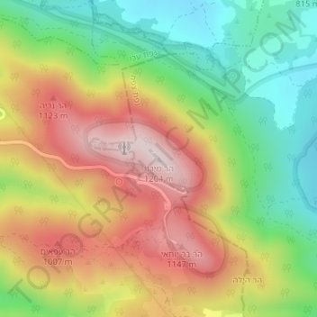
Nombre: Mapa topográfico Mount Meron, altitud, relieve.
Altitud media: 943 m
Altitud mínima: 717 m
Altitud máxima: 1,194 m
Haz una donación
Otros mapas topográficos
Haga clic en un mapa para ver su topografía, su altitud y su relieve.
Meron
Israel > North District > Merom HaGalil Regional Council
Meron is noted for its mountainous terrain and valleys. Among the local attractions are the Meron Vineyards. Meron is conducive to growing grapes for wine as a result of its 600-meter altitude and chalky soil. The vineyard was first planted in 2000 and is part of the Galil Mountain Winery, headquartered in…
Altitud media: 735 m
Haz una donación