
Gracias por apoyar a este sitio ❤️
Haz una donación
Haz una donación
Mapa topográfico Lamar
Haga clic en el mapa para ver la altitud.
Gracias por apoyar a este sitio ❤️
Haz una donación
Haz una donación
Acerca de este mapa
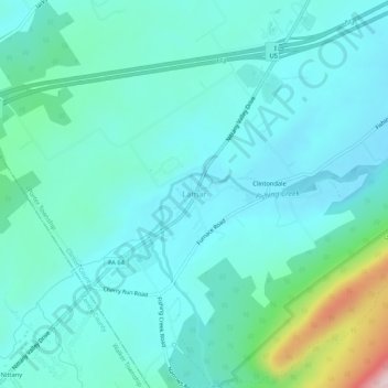
Nombre: Mapa topográfico Lamar, altitud, relieve.
Altitud media: 288 m
Altitud mínima: 224 m
Altitud máxima: 602 m
Gracias por apoyar a este sitio ❤️
Haz una donación
Haz una donación
Otros mapas topográficos
Haga clic en un mapa para ver su topografía, su altitud y su relieve.
Nittany Valley
United States > Pennsylvania > Clinton County > Porter Township
Nittany Valley is in the western part of the Ridge and Valley province of the Appalachian Mountains. During the Appalachian orogeny, the sedimentary rock layers folded up into the Nittany Arch anticline. The arch was an ancient Himalayan scale mountain that towered above what is now the valley. The oldest rock…
Altitud media: 362 m