
Mapa topográfico Chiricahua National Monument
Mapa interactivo
Haga clic en el mapa para ver la altitud.
Acerca de este mapa
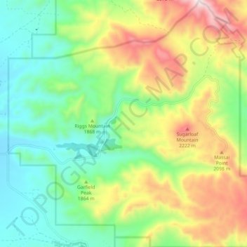
Nombre: Mapa topográfico Chiricahua National Monument, altitud, relieve.
Altitud media: 1,861 m
Altitud mínima: 1,562 m
Altitud máxima: 2,386 m
Otros mapas topográficos
Haga clic en un mapa para ver su topografía, su altitud y su relieve.
Willcox
United States > Arizona > Cochise County
Willcox, Cochise County, Arizona, 85643, United States
Altitud media: 1,274 m
Bakerville
United States > Arizona > Cochise County > Bisbee > Warren
Bakerville, Warren, Bisbee, Cochise County, Arizona, 85603, United States
Altitud media: 1,579 m
Douglas
United States > Arizona > Cochise County > Douglas
Douglas, Cochise County, Arizona, United States
Altitud media: 1,265 m
Cathedral Rock
United States > Arizona > Cochise County
Cathedral Rock, Cochise County, Arizona, United States
Altitud media: 1,774 m
Sierra Vista
United States > Arizona > Cochise County
Sierra Vista, Cochise County, Arizona, United States
Altitud media: 1,507 m
Portal
United States > Arizona > Cochise County > Portal
Portal, Cochise County, Arizona, United States
Altitud media: 1,523 m
Bisbee
United States > Arizona > Cochise County
Bisbee, Cochise County, Arizona, United States
Altitud media: 1,676 m
Whetstone
United States > Arizona > Cochise County
Whetstone, Cochise County, Arizona, United States
Altitud media: 1,324 m