
Haz una donación
Mapa topográfico Warrensville
Haga clic en el mapa para ver la altitud.
Haz una donación
Acerca de este mapa
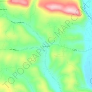
Nombre: Mapa topográfico Warrensville, altitud, relieve.
Lugar: Warrensville, Lycoming County, Pennsylvania, United States (41.30647 -76.96552 41.34647 -76.92552)
Altitud media: 277 m
Altitud mínima: 172 m
Altitud máxima: 459 m
Haz una donación
Otros mapas topográficos
Haga clic en un mapa para ver su topografía, su altitud y su relieve.
Susquehanna State Park
United States > Pennsylvania > Lycoming County > Williamsport
Altitud media: 206 m
Haz una donación
Pine Township
United States > Pennsylvania > Lycoming County
The villages of Oregon Hill and English Center were founded by survivors of the failed English Settlement. Oregon Hill, at an elevation of 1,700 feet (520 m) in the northern part of the township, was the location of two churches, a blacksmith shop, and two stores along with several homes. The settlers of…
Altitud media: 493 m
Haz una donación